Showing posts with label Monarch Pass. Show all posts

Sunday, August 4, 2024

Colorado Rocky Mountains

 We're back in Colorado, starting in Craig and ending the day in Gunnison. This means high elevations over mountain passes and crossing the Continental Divide while enjoying curving, sweeping roads.


We started riding east on US 40 from Craig, riding into the sun through fields and rolling hills. We turned south onto Routt County 27 which is such a fun motorcycle road - hardly any straight sections and all twists and curves.


We turned onto Colorado 131S, another winding and curving road.


We rode along the Colorado River and crossed the river at one point, watching brightly colored boats filled with people enjoying a beautiful day on the water.


Colorado 131 came to an end and we had two options: take I-70 east for 12 miles, or follow US 6 east. We chose US 6 and enjoyed riding through the heavily populated Eagle/Vail and Avon area without battling semi trucks and traffic on the interstate.


US6 ends at US 24 just west of Minturn, and we started climbing up Tennessee Pass toward Leadville. 


A railroad was built here in 1881 to support the mining operations, and mining continues to be important today. This is also the part of the Top of the Rockies Scenic Byway, passing the training area for the 10th Mountain Division during WWII as they prepared for warfare in the Alps. The 2-lane paved road twists and turns with brief interludes of fairly straight roads with amazing high alpine vistas.


We encountered more traffic than any other day during this trip, slowing to a crawl up the mountain behind a long line of cars and trucks hauling oversized loads over the 10,424' Tennessee Pass and then on through Leadville, at 10,119' the highest incorporated town in the United States. We continued on US 24 descending from Leadville toward Buena Vista.


This is part of the Collegiate Peaks Scenic Byway,  57 mile paved route that parallels the Continental Divide at the foot of the Sawatch Mountain Range, the highest concentration of 14,000' or higher peaks in the country.


We hoped to stop for lunch in Buena Vista, but it was packed with tourists so we continued on US 285S alongside the Arkansas River to Poncha Springs


We stopped for lunch at the Hunger Shack in Poncha Springs before continuing on US 50 west over Monarch Pass, at 11,312' on the Continental Divide.


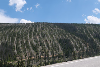
Spruce beetles have killed huge numbers of mature trees in the Rockies in Colorado, and we rode past areas where the Watershed Health Project is removing dead trees to reduce the fuel load for wildfires.


We continued winding down Monarch Pass on US 50, riding through the irrigated valley to Gunnison, our stop for the night. We're looking forward to pizza and locally brewed beer to celebrate a gorgeous ride through the heart of the Rockies in Colorado.


Tuesday, July 25, 2023

Riding home: familiar and new Colorado roads

 We started off the third and last day of our motorcycle trip Monday morning in Leadville, looking forward to more high mountain passes and a road we haven't yet ridden. We started off riding south on US 24, looking out over the snowy Rockies.


Soon the highway started curving and winding along rocky cliffs cut by the Arkansas River that starts near Leadville and ends 1469 miles later at the Mississippi in Arkansas.


We saw a few fly fishermen but no rafts on the river. Soon after we started riding along the Collegiate Peaks, a 57 mile stretch of the largest concentration of mountains over 14,000' in the United States.


We've ridden this way many times, but I'm always awed by the sight of these towering mountains, and even more impressed with hikers who climb them.

South of Buena Vista US 24 meets up with US 285, continuing south past more of the Collegiate Peaks.


In Poncha Springs we turned west onto US 50 and started winding our way up Monarch Pass our highest point for today at 11,312'. There's a ski area just east of the summit, and the gondola is open in the summer to take visitors for a sky-high view of the area.


After riding out into a broad valley, we turned south onto CO 114 - a road we had never been on. To our delight, the first 23 miles were freshly paved, and with no other traffic in sight we zoomed along the road.


We knew more fun was in store when we started seeing road signs warning about twisting curves.


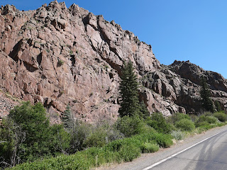
The ride through Cochetopa Canyon is beautiful, with sharp turns through the rocky canyon.


We started seeing signs warning about road construction, and soon came upon the end of the newly paved section of highway. We crossed another pass - this time North Pass at 10,010' that travels along the Continental Divide. This was one of the original routes through the Continental Divide as it's a relatively gentle climb and descent - for a motorcycle, but not for someone with a horse and wagon!


CO 114 ends at Saguache where we turned once again onto US 285 south. We rode this route through the San Luis Valley in reverse on the first day of this trip, and started thinking about where we might stop for lunch as we passed bright green irrigated fields bordered by dusty brown desert.


We stopped in Del Norte on US 160W for lunch. It's often challenging to find a restaurant open on a Monday, and we were lucky to find the Three Barrel Brewing Company open 7 days per week. Leaving Del Norte we had about 90 miles left on our trip, riding over Wolf Creek Pass at 10,856'. This is a busy highway with trucks and RVs, and because the road has several tight turns and steep elevation changes, there are runaway truck ramps - just in case.


Riding down the Pass into Pagosa Springs we were just a few miles from home. We rode through incredibly beautiful areas over these past three days, yet the final stretch toward home is one of the most gorgeous areas in the entire state.


Friday, July 14, 2017

Colorado mountain passes plus rain and hail

Yesterday our ride from home in Arizona to Cortez, Colorado was hot and sunny. Today, on our second day of our Colorado trip, we spent the day dodging rain and hail with temperatures dipping into the low 50's. We were ready for it!


We spent last night at the Retro Inn in Cortez, and said good-bye to the Elvis statue on the front lawn as we headed out of town.

We rode east on 160, passing Mesa Verde National Park, where there are over 600 cliff dwellings that were home to the Ancestral Pueblo people from AD 600-1300. We stayed here several years ago and absolutely loved the ride up to the top of the mesa along the curving road, and the ranger-led tour gave us an in-depth look at the cliff dwellings.


As we rode through the Mancos Valley into the San Juan National Forest, storm clouds starting building in front of us.


160 took us into Durango, where we turned north onto 550 for a motorcyclist's dream ride through the mountains with hairpin turns, curving roads, and stunning views.


The storm clouds kept building as we climbed Coal Bank Pass at 10,640', and then onto Molas Pass at 10,910' where we stopped for a short break.


It started raining soon after we left Molas Pass, and luckily we stopped to put on our raingear before the temperature dropped 15 degrees and it started raining hard. We rode in and out of the rain as we descended into Silverton, an old mining town that is a National Historic Landmark and the southern end of the Million Dollar Highway that winds through the San Juan Mountains from Silverton to Ouray. In the late 1800's this area was prime mining country, and remnants of mining activity are easily visible from the highway.

We've ridden this route before, although never in the rain. The narrow 2-lane highway hugs the mountains on one side and drops off thousands of feet - without guardrails - on the other. I managed to get some video in-between the rain as we headed into Ouray.


Ouray sits at 7,792' nestled in the San Juan Mountains alongside the Uncompahgre River. We stopped for lunch and sat outside on the roof enjoying our sandwiches and watching the traffic on the street below us - until it started to rain again.


550 winds along the Uncompahgre River to Montrose, where we turned east on 50. It was a good thing we kept the raingear on, as we rode through intermittent rain and a couple of spots of hail. It's fun to watch the rain streaming down from the clouds - until we're in the middle of it!


We rode along the Curecanti National Recreation Area, a series of three reservoirs along the Gunnison River. Normally we see numerous boats on the water, but the weather today kept everyone home.


We even managed a photo opportunity during a delay for road construction, and were lucky that the rain held off while we were stopped.


We crested the last pass of the day, Monarch Pass on the Continental Divide at 11, 312' - our highest pass of the day. Storm clouds and rain were all around us as we rode down the Pass into the Arkansas River Valley toward Salida, our stop for the night.


We had been looking forward to this day since we planned our trip since we love this mountain route on the BMW. Tomorrow we have a shorter ride planned to Boulder, where we'll stop for the weekend to visit our kids. Our trip home starts again on Monday - and since we haven't planned our route yet, you'll be surprised right along with us!

Tuesday, June 28, 2016

Twisties and sweepers through the Rocky Mountains

A long day on the BMW is worth it when we get to ride through hairpin turns and long sweeping turns in the Rocky Mountains in Colorado.


We started the second day of our trip in Farmington, NM and quickly crossed into Colorado near Durango. We stayed on US Route 550 heading north, winding and twisting our way on the Million Dollar Highway that runs through Silverton to Ouray.


The 2-lane, narrow road, lack of guardrails, steep drop-offs and jaw-dropping scenery make this one of our favorite rides.


Gold was mined here in the San Juan Mountains with 13 peaks that top 14,000'. This area likes to call itself the "Switzerland of America" because of the steep, forested, and snowy peaks.


Once we passed through Ouray we continued north on Route 550 into Montrose, passing through a wide, green valley along the Uncompahgre River.


In Montrose, we turned east on US Route 50, a ride we've done several times. Route 50 runs along the Gunnison River and the 20-mile long Blue Mesa Reservoir.


We rode through steep, craggy gorges that opened up into wider valleys, and spotted several rafts zooming down the rapidly running river.


We twisted our way up and over Monarch Pass on the Continental Divide in the Sawatch Mountain Range, with panoramic views as we descended down into the valley and along the Arkansas River.


We chose a new route for the final miles north to Denver, starting with 9 North just west of Canon City on the Gold Belt Scenic Byway that runs along the western slope of Pike's Peak where gold was discovered in 1890.

Riding on winding, sweeping, 2-lane paved roads with almost no traffic, we enjoyed views of steep, wooded hills, snowy mountain peaks, and rushing streams.


To get into Denver, we rode the final miles of the day on highways packed with later Friday afternoon traffic. From Denver, you can see the snow-topped Rocky Mountain Peaks that we rode through earlier in the day.

We're spending the weekend in Denver with our kids, and will get back on the BMW on Monday, heading north into Wyoming.