Tuesday, July 25, 2023

Riding home: familiar and new Colorado roads

 We started off the third and last day of our motorcycle trip Monday morning in Leadville, looking forward to more high mountain passes and a road we haven't yet ridden. We started off riding south on US 24, looking out over the snowy Rockies.


Soon the highway started curving and winding along rocky cliffs cut by the Arkansas River that starts near Leadville and ends 1469 miles later at the Mississippi in Arkansas.


We saw a few fly fishermen but no rafts on the river. Soon after we started riding along the Collegiate Peaks, a 57 mile stretch of the largest concentration of mountains over 14,000' in the United States.


We've ridden this way many times, but I'm always awed by the sight of these towering mountains, and even more impressed with hikers who climb them.

South of Buena Vista US 24 meets up with US 285, continuing south past more of the Collegiate Peaks.


In Poncha Springs we turned west onto US 50 and started winding our way up Monarch Pass our highest point for today at 11,312'. There's a ski area just east of the summit, and the gondola is open in the summer to take visitors for a sky-high view of the area.


After riding out into a broad valley, we turned south onto CO 114 - a road we had never been on. To our delight, the first 23 miles were freshly paved, and with no other traffic in sight we zoomed along the road.


We knew more fun was in store when we started seeing road signs warning about twisting curves.


The ride through Cochetopa Canyon is beautiful, with sharp turns through the rocky canyon.


We started seeing signs warning about road construction, and soon came upon the end of the newly paved section of highway. We crossed another pass - this time North Pass at 10,010' that travels along the Continental Divide. This was one of the original routes through the Continental Divide as it's a relatively gentle climb and descent - for a motorcycle, but not for someone with a horse and wagon!


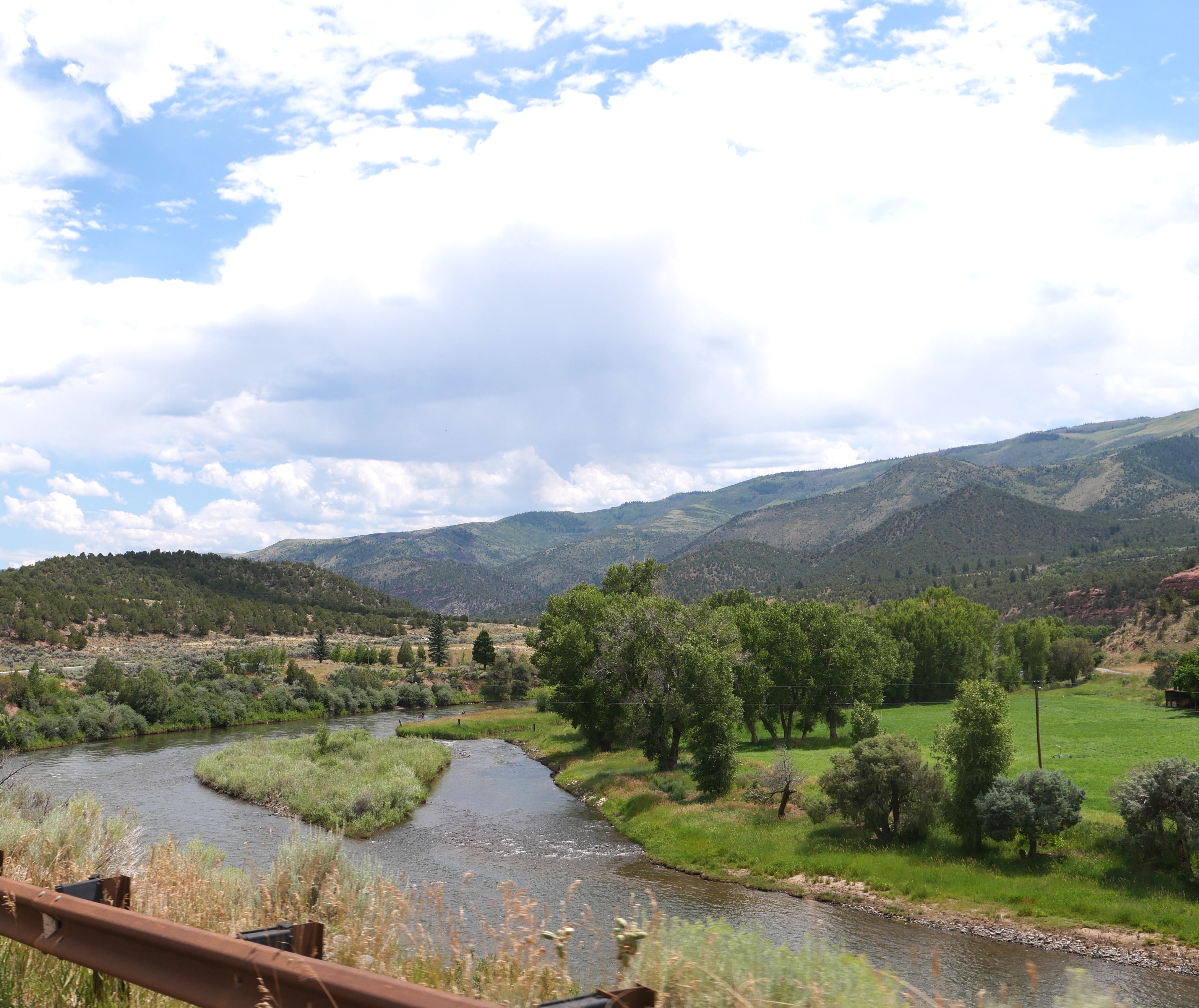
CO 114 ends at Saguache where we turned once again onto US 285 south. We rode this route through the San Luis Valley in reverse on the first day of this trip, and started thinking about where we might stop for lunch as we passed bright green irrigated fields bordered by dusty brown desert.


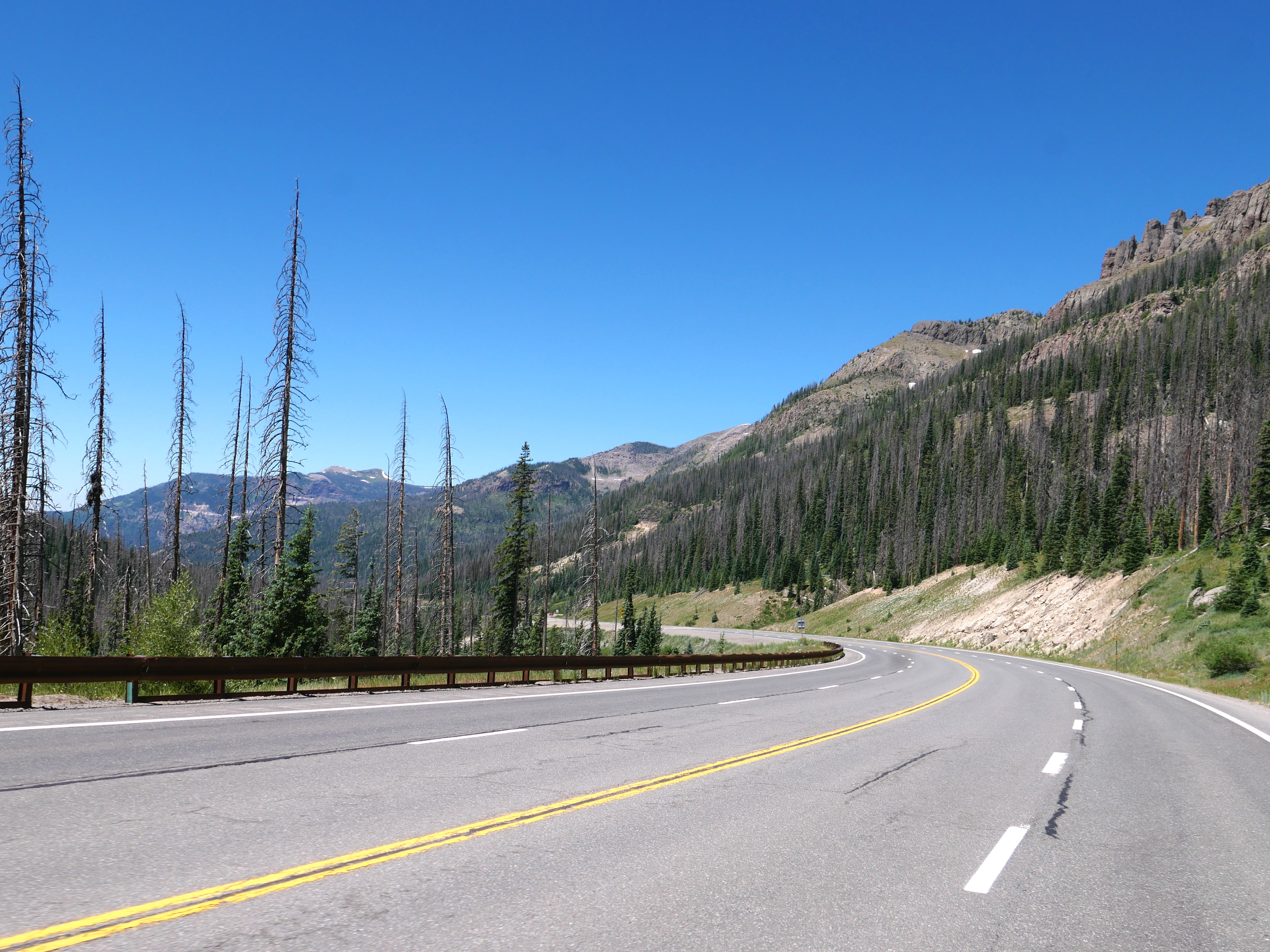
We stopped in Del Norte on US 160W for lunch. It's often challenging to find a restaurant open on a Monday, and we were lucky to find the Three Barrel Brewing Company open 7 days per week. Leaving Del Norte we had about 90 miles left on our trip, riding over Wolf Creek Pass at 10,856'. This is a busy highway with trucks and RVs, and because the road has several tight turns and steep elevation changes, there are runaway truck ramps - just in case.


Riding down the Pass into Pagosa Springs we were just a few miles from home. We rode through incredibly beautiful areas over these past three days, yet the final stretch toward home is one of the most gorgeous areas in the entire state.


Monday, July 24, 2023

High elevation riding

 We started our ride Sunday in Fairplay, Colorado at 9,954' and 284 miles later finished our ride in Leadville, Colorado at 10,158'. We intentionally took the long way around to enjoy riding in the Rockies. As the crow flies, only 16 miles separates these two old mining towns.


We took CO 9 north out of Fairplay and soon started climbing up Hoosier Pass at 11,542'. Our approach from south to north is less steep and more sweeping turns compared to the north side which features hairpin turn switchbacks and 8% grades - tons of fun on the BMW!


We stopped at the summit for a photo since our address in Prescott, Arizona was Hoosier Pass!


As we continued north on CO 9, we passed numerous ski houses, signs that we were getting close to Breckenridge - both the town and the ski area. Like many towns in this area, Breckenridge was founded by miners during the 1859 Pike's Peak gold rush. Once the ski area opened in 1961, the town growth exploded and it's packed with tourists all year round.


Until we reached Breck we enjoyed little traffic and zooming along the road. All of that changed over the next few miles as we rode through tourist and ski area central - Frisco and Silverthorne,  - at times needing to ride east on I70 for a few miles. This is a gorgeous area but challenging for us to enjoy while riding in a sea of traffic. The one bright spot is the huge Dillon Reservoir  created in the 1960's to provide water for Denver and today filled with all types of water sport recreation.


We were thrilled to ride out of the traffic as we continued north on CO 9, taking the long way to our eventual destination of Leadville so that we could enjoy more Colorado riding. Our route took us along the Blue River, a 65 mile long tributary of the Colorado River that is dammed to form the Green Mountain Reservoir that was built between 1938 and 1943.


We crossed the Colorado River just before we reached Kremmling, and then turned north/east onto US40, riding past yet another reservoir - this time the Wolford Mountain Reservoir

US 40 goes into Steamboat Springs, and along the way we saw numerous signs advertising F.M. Light & Sons western clothing store, established in 1905 and continuing to sell western wear today.


Our route took us over two passes over the Continental Divide. First up was Muddy Pass, at 8,772' one of the lower passes on our trip. There aren't any hairpin switchbacks on either side of the pass, and then just a few miles down the road we rode up Rabbit Ears Pass at 9,426'. We could see the iconic rabbit ears rock formation long before we actually rode up the pass.


We made a quick detour into Steamboat Springs for lunch and then continued south on CO 131 through rolling hills and ranchland.


We then came upon the Colorado River again, this time riding along the river and watching several rafting groups before we crossed at State Bridge. It was getting hot and I kept imagining how cool it would feel to be rafting today.


After crossing the Colorado, we turned south on US 24 which took us into Leadville. Our route today was a large upside-down "U" shape, so now we were headed back into busy traffic as we rode through the ski towns of Beaver Creek and EagleVail. We finally left the traffic behind as we started climbing up Tennessee Pass, reaching 10,424'.


This stretch of US 24th is designed the US 10th Mountain Division Highway to honor this Army division that was the first to train in winter war, starting in 1942. This is also part of the Top of the Rockies scenic byway that over 75 miles connects several old mining towns, traveling through three national forests - all on a highway that is over 9,000' elevation.

One of my favorite parts of this route is the suspension bridge built in 1940 over the Eagle River.


This route has it all:  sweeping turns, tight hairpin switchbacks, huge stands of aspens, long views of the valley far below, and snow peaked mountains that rise over 14,000'.


We've ridden this route a few times, but this is our first time staying overnight in Leadville. It's Mike's birthday, and we're planning to celebrate in this still vibrant historic mining town.


Saturday, July 22, 2023

Colorado mountains and rivers

 We started the first of a 3-day motorcycle trip today, riding east from Pagosa Springs on US 160E, riding over Wolf Creek Pass in the San Juan mountains over the Continental Divide. We rode this route in reverse last Sunday, so check out that post for photos of the twists and turns up and over the mountains.

Once in Del Norte we turned north on CO112, riding through the San Luis Valley, one of the largest high altitude (about 8,000') valleys in the world and home to ranches and farming.


It's the end of July, but riding at this altitude the temperature is comfortable in the mid to high 70's. When we reached Saguache (derived from a Ute word that means sand dunes, referencing the nearby Great Sand Dunes National Park) we turned onto US 285, continuing to head north through the San Luis Valley.

We rode over Poncha Pass, at just 9,010' one of the lowest passes in Colorado. Winding down the north side of Poncha Pass we came into Poncha Springs, and stopped at the Flamingo food truck for lunch just as it started to rain. This is a do not miss stop - delicious food and friendly people. Luckily there is an indoor place to eat, and by the time we finished lunch the rain stopped.


We turned east on US 50 to ride through Bighorn Sheep Canyon along the Arkansas River. This was our first time riding the BMW through this area, and the twisting road along steep rocky cliffs and clear water was a ton of fun - even though we didn't see any sheep.


Just past Parkdale we left the Arkansas River and turned north on CO 9 and climbed out of the river valley into South Park, one of three high altitude basins in Colorado. 


We rode 280 miles today, twisting over mountain passes and through river valleys, ending up on a straight road at over 9,000' elevation with views of snowy Rocky Mountain peaks in the distance. Our stop tonight is in Fairplay, founded in 1859 as part of the Pike's Peak Gold Rush. You can still pan for gold in the Middle Fork of the South Platte River that runs through town. We've ridden through Fairplay several times, and this will be our first time staying here.

Tomorrow our route will take us over more mountain passes through the heart of the Rockies. We're looking forward to it!


Sunday, July 16, 2023

Sunday morning ride

 We decided to ride in a big circle today, heading south from Chromo, Colorado to Chama, NM and then turning east on CO 17. This is a twisty 2-lane paved road that winds through the Sangre de Cristo mountains that are the southernmost part of the Rockies straddling the Colorado and New Mexico border.


We rode over Cumbres Pass at 10,0220' and as we descended toward the east we left behind green meadows and started seeing towering rocky cliffs as we headed into the San Luis Valley


At over 7,600' elevation, this 122 mile long, 74 mile wide high desert valley is home to agriculture and ranching. This area was originally home of the Utes, later explored by the Spanish and part of Mexico, and ceded to the United States in 1848 after the Mexican-American war.


CO 17 meets up with CO 285 in Antonito, and we then headed west on US 160 in Monte Vista. 


Up until this point we saw very little traffic, enjoying the road to ourselves. US 160 is a much more heavily traveled road and Mike zoomed past slower moving RVs and trucks at every opportunity.


We left home about 8:30am and by the time we reached South Fork we were hungry - and stumbled upon a superb food truck/bar/outdoor spot:  Rachel's


They had a small yet unique and delicious menu - we shared KoKo's Huevos and a Banana Split parfait while sitting at a picnic table in a shaded area. We were too early for the band that starts at noon on Sundays and are already planning another trip here.


We continued on US 160W over Wolf Creek Pass in the San Juan Mountains, crossing the Continental Divide at 10,857' before we descended down into Pagosa Springs.


We live about 25 miles south of Pagosa Springs, so we stopped at the Farmer's Market for fresh Palisade peaches, cherries and sweet corn before turning south on US 84 and home.

We rode 220 miles in about 4 hours (including the two stops) on a beautiful July summer morning. Fabulous motorcycle riding is one of the big reasons we live here, and today is a fantastic example of a perfect motorcycle day.