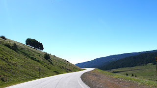
We decided to ride in a big circle today, heading south from Chromo, Colorado to Chama, NM and then turning east on CO 17. This is a twisty 2-lane paved road that winds through the Sangre de Cristo mountains that are the southernmost part of the Rockies straddling the Colorado and New Mexico border.
We rode over Cumbres Pass at 10,0220' and as we descended toward the east we left behind green meadows and started seeing towering rocky cliffs as we headed into the San Luis Valley.
At over 7,600' elevation, this 122 mile long, 74 mile wide high desert valley is home to agriculture and ranching. This area was originally home of the Utes, later explored by the Spanish and part of Mexico, and ceded to the United States in 1848 after the Mexican-American war.
CO 17 meets up with CO 285 in Antonito, and we then headed west on US 160 in Monte Vista.
Up until this point we saw very little traffic, enjoying the road to ourselves. US 160 is a much more heavily traveled road and Mike zoomed past slower moving RVs and trucks at every opportunity.
We left home about 8:30am and by the time we reached South Fork we were hungry - and stumbled upon a superb food truck/bar/outdoor spot: Rachel's.
They had a small yet unique and delicious menu - we shared KoKo's Huevos and a Banana Split parfait while sitting at a picnic table in a shaded area. We were too early for the band that starts at noon on Sundays and are already planning another trip here.
We continued on US 160W over
Wolf Creek Pass in the San Juan Mountains, crossing the Continental Divide at 10,857' before we descended down into Pagosa Springs.
We live about 25 miles south of Pagosa Springs, so we stopped at the Farmer's Market for fresh Palisade peaches, cherries and sweet corn before turning south on US 84 and home.
We rode 220 miles in about 4 hours (including the two stops) on a beautiful July summer morning. Fabulous motorcycle riding is one of the big reasons we live here, and today is a fantastic example of a perfect motorcycle day.


