Tuesday, May 20, 2014

The last day of our 2120 mile trip from Arizona to Boise and back on our BMW motorcycle

Today was our last day of a 2120 mile trip from our home in Prescott, AZ to Boise, ID and back. It's been windy most of the way, but today the weather forecast was for wind gusts up to 47 mph, so we started the 2.5 hour ride early to beat the worst of the wind.


We started in Kingman, AZ in the Mojave Desert with views of the Hualapai Mountains which range over 8,000'. Kingman is at 3336' elevation, and we wound our way through the Mojave and Sonoran Deserts with views of the shorter Aquarius Mountains at a little over 5,000'. We've been on US Route 93 since early yesterday, starting in Ely, NV. The section from Wickieup to Wickenburg is called the Joshua Tree Parkway of Arizona, and we saw fields of this gnarly, scrubby tree that Territorial Governor John Fremont called "the most repulsive tree in the vegetable kingdom" when he first saw them on a trip through the desert in 1844.

US Route 93 from Kingman to Congress

We turned north off Route 93 and headed on a winding trip up Route 89 toward home. It really is "up" because we climbed in elevation from 3000' in Congress to 4,700' in Yarnell and then even higher to over 6,000' as we rode through the Weaver Mountains into Prescott.

from Congress toward Yarnell

These are favorite roads for motorcycle riders, and we passed two groups of riders today as we twisted and curved our way through the mountains.

The wind picked up as we turned into our street, and by the time we had the bike unpacked I could hear the wind howling through the trees and around the house.

We celebrated as we saw the BMW odometer roll over to 20,000 miles on the first day of our trip. The last week runs together:  did we ride up the unexpected mountain pass on the first or second day? Why does the time zone change from Mountain in Utah and Idaho to Pacific in Nevada? Is today really Tuesday? I have vivid pictures in my mind of long stretches of lonely desert with snowy mountain peaks towering over windmills in the valley, lush green parks in Boise, and friendly people in small towns when we stopped for gas or lunch. I remember the feel of the hot wind as we rode through 90 degree temperatures on a bright sunny day around Lake Mead, and the cold wind that snaked under my jacket when we crossed the snow covered mountain passes in Utah.

John Muir, one of the first promoters of preserving wilderness areas, said that "The clearest way into the Universe is through a forest wilderness." I feel he would agree with me that a desert or mountain wilderness also qualifies.


Monday, May 19, 2014

Out of the cool mountains into the hot desert on our BMW motorcycle

Today was a day of contrasts:

We started at 10 am under cloudy, grey skies with temperatures hovering just below 60 degrees.4 hours later we peeled off long sleeve shirts and jacket liners as we rode south toward Las Vegas under a bright sun with the temperature in the mid 90’s.

US 93 near Ely, NV in the Humboldt National Forest

Most of the day we rode for miles without seeing any traffic, and at one point traveled 113 miles between towns. Then we rode into metropolitan Las Vegas, skirting as much of the city as possible but still riding in 4-lane stop-and-go traffic.

US 93 toward Pioche

At times the flat desert landscape was covered with green sagebrush, then we swept around long curves through rocky bluffs, passed bright blue lakes and swampy areas, rode through what looked like large mounds of gravel, slowed down to take in the pitted, towering red rocks in the Valley of Fire, and rode through the canyons in the Lake Mead National Recreation Area. All of this in Nevada!

US 93 near Caliente, NV

We traveled 490 miles today, starting in Ely (which I learned during a conversation with an elderly gentleman during a gas stop in Panaca is pronounced “Eee-lee”; he also told me he talks with many tourists from all over the world who enjoy learning about the American southwest, and that the Italians are most interested in finding the whore houses) and riding south to Kingman, AZ.

I never tire of looking at mountain ranges, many of them topped with snow. The majority of this week-long trip we became used to the desert landscape with sagebrush and scrawny pinyon pines, and then were surprised today by the Pahranagat lake and swampy wildlife reserve that seem out of place in dry Nevada. The spring-fed lake in the Mojave Desert is home to thousands of birds on the Pacific Flyway migration route.


Mike planned a route around Las Vegas that took us through the Valley of Fire, the oldest state park in Nevada. It takes its name from the deep red sandstone formations formed 150 million years ago from sand dunes followed by uplifting, faulting, and erosion. 

We've been through red sandstone formations in Sedona, AZ near our home, but the Valley of Fire is even more impressive because of it's size and wide open spaces between the towering red sandstone cliffs.

ride through the Valley of Fire

This is a perfect time of year for a visit to the park:  we saw only 3 cars along the 10.5 mile road which gave us time to ride slowly and pull over to the side for photos.

The 2,337 square mile Lake Mead National Recreation Area joins the Valley of Fire, and we caught glimpses of the lake as we rode along the Northshore Road. This is a desert landscape of canyons, bluffs and cliffs, and in fact three desert ecosystems meet here:  Mojave, Great Basin, and Sonoran.


It was a shock to my system to leave the quiet desert and turn onto 4-land highways around Las Vegas. We crossed the Hoover Dam on the new US Route 93 bridge into Arizona, and rode the last hour into Kingman. We stayed in a hotel right on the old Route 66, and learned from the trivia on the restaurant menu that Clark Gable and Carole Lombard eloped here in 1939. 

We ended the day with one more contrast:  last night we stayed in small, rural Ely, NV and tonight we're in busy Kingman. With 28,000 people, Kingman is nine times larger than Ely. Both are county seats, yet worlds apart. 


Sunday, May 18, 2014

Straight roads through the high desert on our BMW motorcycle

We spent yesterday in Boise, Idaho where I ran the Famous Idaho Potato Marathon and then we explored the downtown area. We discovered that one of the the largest populations of people with Basque heritage live in and around Boise. The Basque Block is a part of the vibrant downtown with restaurants and a museum, and we sat outside at Bar Gernika and watched people biking and walking on a beautiful, sunny afternoon.

Today we started back home, riding southeast on Interstate 84 for about 80 miles before turning off onto US Route 30. The day was cloudy, overcast, windy and cooler than our trip north, and we both wore part or all of our raingear for warmth at various times during the day. We loved having the Viking Cruise Roll Bag with the large zippered top opening for easy access to store our raingear when the weather warmed up, and then to take the raingear back out when the skies darkened and a cold wind picked up.

This part of US 30 is the Thousand Springs Scenic Byway that runs through the Snake River Canyon. We rode through bright green irrigated fields, crossed the Snake River, saw waterfalls spilling from the top of high bluffs, and watched windmills turning in the stiff wind. There are several fish hatcheries in this area that raise 70% of the trout produced in the United States.


This part of Idaho is completely different than anything we've seen so far, with towns every 10-20 miles, rivers and creeks, and leafy green trees. When we're on a motorcycle we notice the different smells, and today I was thrilled to smell and see lilac bushes, one of my favorite signs of Spring when we lived in Vermont.

We turned south onto US Route 93 for the rest of our 380 mile trip today, and as soon as we crossed into Nevada at Jackpot - an apt name for a town with several casinos - the landscape changed into the familiar high desert mountains, canyons and bluffs covered with rocks and sagebrush.


US Route 93 splits the Great Basin that covers most of Nevada and part of Utah. We saw snow-peaked mountains to the East and West, and the traffic thinned to tractor-trailers hauling freight and cattle, local pick-up trucks, and a few other motorcycles. Towns are much farther apart, with one sign warning that the next services were 115 miles away.


Our stop for tonight is Ely, where we ate lunch in the Hotel Nevada on our trip north three days ago. Ely was founded as a stagecoach stop along the Pony Express, and later became a booming copper mining town. We ate dinner in the Silver State Restaurant and chatted with the friendly staff about the town and a grandson riding the PBR rodeo circuit out of Michigan.

Tomorrow our plan is to continue south on Route 93, riding around the outskirts of Las Vegas and finishing the day in Kingman, AZ. We're expecting sunnier skies with the same windy conditions, looking forward to more adventures on the BMW.

Friday, May 16, 2014

Elko, Nevada to Boise, Idaho on the BMW motorcycle

Traveling on our BMW motorcycle gives us the opportunity to find less-traveled roads and explore parts of the country we would never see on the Interstate highway system.

Today we started in Elko, NV and rode 259 miles north to Boise, ID. We rode for 190 miles on Nevada 225/Idaho 51 before we made our first turn of the day.


Sagebrush lined the road with views of the Independence Mountains to the west. The only trees we saw were around isolated ranches; otherwise the land was covered in rocks or sagebrush.


The road twisted through the Humboldt-Toiyabe National Forest, rising up and down and then sweeping around the steep, rocky hills that fell straight down to the narrow - or often nonexistent - highway shoulder.


We've been traveling through the high desert for the past two days on our trip from Arizona to Boise, Idaho and I was excited to see the Wild Horse Reservoir that stretched out into the valley. It was built in the 1930's to store water for irrigation, and is also stocked with trout and bass for fishing.


Owyhee, NV was the first town we came to - 97 miles after we started our trip today. It's on the Duck Valley Reservation, home to the Shoshone and Paiute tribes. Luckily there was one gas station/grocery store in town so we could take a break and fill up the tank.

We crossed into Idaho less than one mile from the gas station, and rode on what was now called Idaho 51 - the same road we'd been on all day, just renumbered from Nevada to Idaho. The first 43 miles the road shot straight through the flat landscape with sagebrush covering every visible area. This is open range country, with signs warning us to watch out for 'cows on the road'.

Then the road started curving and sweeping around rolling and rocky hills, keeping the ride interesting until we finally started seeing bright green, irrigated fields and towering stacks of hay.


We crossed the Snake River and left the isolation of a 2-lane highway with almost no traffic and no stop signs or traffic signals for a city highway with stores, gas stations, traffic and stoplights.


It's a shock to our system to see green grass, rivers filled with water instead of a mere trickle or dry, and city congestion. Boise is the capitol of Idaho, and the most populous city in the state with just over 200,000 people and over 600,000 in the metropolitan area.  Early settlers must have felt the same way, because the name "Boise" comes from the French traders who named the river "la rivière boisée" which translates to "the wooded river".

Tomorrow I run the Famous Idaho Potato marathon along the Boise River greenspace. We'll take a rest day from the motorcycle, then Sunday head for a 3-day trip home along a different route, looking for new roads to explore.

Thursday, May 15, 2014

Discovering Nevada on the BMW motorcycle

On our 459 mile trip today from Cedar City, Utah to Elko, Nevada we discovered:

Pioche, NV once had over 10,000 residents and was the largest mining town in southern Nevada. It was well-known as a lawless town of hired gunmen where supposedly 75 men were killed before anyone died of natural causes. We stopped at Tillie's Mini Mart (selling gasoline to vaseline) for gas in this quiet town of 1000 people.


Route 50 in Nevada, the loneliest road in America where we rode over 100 miles from one small town to the next.


After 36 miles of pavement and seeing only one other vehicle, Nevada Route 892 turned into a hard-packed, rutted dirt road. We turned around and retraced our route, seeing only one other vehicle. That was a total of 2 vehicles in 72 miles.


The speed limit on remote 2-lane highways in Nevada is 70 mph. Mike routinely piloted the BMW between 85 and 95mph.


More animals - rabbits, deer, cows - than people as we traveled in the middle of the Silver State.


The Hotel Nevada in Ely opened in 1929 (at 6 stories the tallest building in the state at that time) and hosted celebrities including Mickey Rooney and Clark Cable in the hotel/casino/restaurant that served bootlegged alcohol 24 hours/day throughout Prohibition. We ate lunch in the restaurant with motorcyle-theme upholstery on the chairs.


Snow-capped mountain peaks reaching over 10,000' and long valleys, one with a 14-mile long dry, sandy lake bed. During lunch in Ely, the waitress told us it snowed in town last week, and that we're lucky to experience 70-degree temperatures and sunshine today.


Tomorrow we ride into Boise, Idaho for the marathon Saturday. I wonder what we'll discover?

Wednesday, May 14, 2014

BMW trip to Idaho: jaw-dropping, unexpected scenery


We've lived in Arizona for 9 months and today was the first time we've seen the Grand Canyon, even though it's only a 2 hour ride away. "Grand" doesn't do it justice:  the depth, length, width and sheer volume of sensory information that hit us when we stepped to the edge and looked out took our breath away.


We've been planning a trip to Boise, ID for the past 2 months, but until breakfast this morning we didn't plan on stopping at the Grand Canyon. Mike looked at the map and decided to change our plans for our initial route, which led us straight to the Grand Canyon.

This was our first trip with the Viking Cruise Roll Bag sent to us for testing and review by Motorcycle House. It fit snugly on top of our tail bag, held in place by the 4 bungee tie downs. I liked having outside zippered pockets for our maps and a bottle of water, and getting in and out of the large top opening was a breeze.


On the trip north to the Grand Canyon we rode in and out of the Kaibab National Forest, a 1.6 million acre forest that borders both the North and South rims of the Grand Canyon. We spotted 3 elk in the trees off to the side of the road and saw several large raptor nests at the very top of pine trees.

Because the Grand Canyon stretches almost 300 miles across Arizona, we followed Route 64 east even though our eventual destination lies west. We rode through the Painted Desert in the Navajo Nation, past mounds of stone that look like sand dunes, rock formations with striped colors, pink rocks with wavy patterns, and craggy cliffs with stripes of white, pink and brown.


My stomach growled for over an hour until we came to the Cameron Trading Post where we talked with a German leading a motorcycle tour group through the Southwest. We saw several groups of 10-15 motorcycles today, and discovered that many are Europeans traveling through the US.

I tried Navajo beef stew and fry bread the size of a dinner plate, and Mike ordered the prickly pear milkshake to go with a cheeseburger. Fry bread originated out of necessity when the US government forced the Navajo to leave their homeland in Arizona and resettle to New Mexico, a walk of several hundred miles known as the Long Walk. To prevent starvation, the government provided flour, lard and sugar and fry bread was born. I pulled off three small pieces to eat with the stew, then discovered the pool of oil on the plate and decided to skip the rest of the bread in favor of trying Mike's shake.

After lunch we continued north on 89 into Page, Arizona and caught glimpses of Lake Powell, created in 1963 when the Glen Canyon Dam was built across the Colorado River.


We crossed into Utah and rode along the Vermillion Cliffs National Monument, another amazing area filled with sand dunes and rock cliffs in a variety of colors due to different minerals.


As we turned west onto Utah Route 14, we had no idea that we would climb to over 9,000' and the temperature would drop below 50 degrees. The road twisted and turned as it climbed out of the desert into the Dixie National Forest. We rode past steep green meadows dotted with Swiss-style chalets and rushing creeks filled with melting snow - although there is still snow blanketing the higher elevations.


We stopped at Navajo Lake, formed by lava flow millions of years ago. It's only 25' deep, and surrounded by fields of black basalt rocks.


We ended our 429 mile trip zooming down route 14 into Cedar City, UT, our stop for the night. At some points the sheer rock walls towered above us blocking out the late afternoon sun.


 The day was filled with unexpected scenery, unplanned stops for photos and lunch, and chance conversations with motorcycle riders looking for adventure. Tomorrow we cross into Nevada, continuing our trip north.

Monday, May 12, 2014

This is a really nice motorcycle touring bag!

I never know what to expect when I order something from a catalog or online. Sometimes the item is exactly as I pictured it, often the quality or size aren't what I expected, and every once in awhile the item is even better. We're thrilled that Motorcycle House sent us a complementary Viking Cruise Roll bag and asked for our honest review.

We leave in two days for a week-long trip to Boise, Idaho where we're going to put the bag to good use.


This is an impressive motorcycle bag that truly exceeds our expectations. It has two narrow round zippered expandable pockets on either side, and another larger zippered pocket with additional internal pockets on the front. The rear-facing side has a silver reflecting strip, a safety feature we appreciate.

The zipper on top reveals one large, padded interior section that easily holds my helmet. The top opening expands for easy packing and unpacking and the zippered top has three smaller additional pockets. There's a separate rain cover and also a removable bottom piece that reveals 4 bungee cords. We're both impressed with the sturdy quality, good looks with black leather accents, and roomy compartments.

 view with the zippered top open, showing the three pockets on the inside of the top flap

Tomorrow we'll pack up everything for the trip to Boise, and Mike will figure out how to attach the Viking bag to the top of our tail bag. Look for photos of the bag on our BMW as we head out on Wednesday. We'll bring the rain cover along but hopefully it won't be necessary.

Thursday, May 8, 2014

Motorcycle gear: form and function

One of my friends is a talented and creative artist, and she taught me about form and function. She looks for functional objects that have interesting and artistic forms, and often loves an object just because of its stylish form even when it has no set function.

gorgeous and funky leather scarf by Sara Gay

On a motorcycle everything has to serve a function, and often I sacrifice form. Case in point:  I look like the Pillsbury Doughboy in my bulky, yet highly visible and protective Olympia Motorsports gear.


When I put on the Frogg Toggs raingear - that keeps me perfectly dry and toasty warm when we're riding through a driving downpour or high mountain passes - I look like a double version of myself.


Periodically I wish I could ride pillion wearing flip-flops, short-shorts, and a skimpy leather top - then I come to my senses and realize that in motorcycle travel, safety trumps style.

Sometimes we get lucky and our gear serves a necessary function along with great form and style. Our BMW motorcycle boots are stylish and they're also 100% waterproof and extremely comfortable. Our feet stay perfectly dry, even riding for hours in the rain.

I'm excited to have the opportunity to test and blog about gear from Motorcycle House and Viking Bags. They're sending us a couple of items, we'll try them out, and I'll blog about them. We have a couple of extended trips coming up plus spontaneous shorter rides when the mood strikes us to get out and explore. Stay tuned!

Monday, May 5, 2014

A spontaneous motorcycle trip from New Mexico home

Mike put together a great route for our return trip from Farmington, NM back to Prescott, AZ.

We didn't follow any of it.

I ran the Shiprock Marathon on Saturday, a 26.2 mile point-to-point route that took us right past Shiprock, or Tsé Bitʼaʼí, "rock with wings" or "winged rock" in Navajo. 
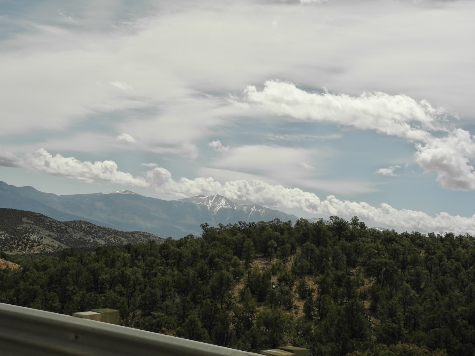
Shiprock is actually a monadnock, or center of an ancient volcano that probably erupted 27 million years ago. Shiprock rises over 1,500' above the plain, with sheets of rock known as dikes radiating away from the central rock formation. Shiprock holds special significance to the Navajo, and is a central feature in their history and religion. We spent the majority of the day riding through the Navajo Nation, an area about the size of West Virginia.

You can see Shiprock from miles away, but I wanted Mike to experience it up close on N13, the 2-lane paved Navajo Nation road, as I did when I ran past it during the marathon.


After the marathon we talked with some local runners who told us N13 continues out into Arizona. We rode by Shiprock and figured we'd use the Garmin to take us back on our planned route. Following N13 into Arizona, we rode into the Red Valley and were amazed by the numerous red rock formations and towering cliffs.


We were thrilled when we saw the sign that N13 is closed in the winter, which told us that we were in for some twisting climbing and descending. Riding through the Buffalo Pass in the snowcapped  Lukachukai Mountains was great fun, with steep ascents until we reached 8,400' and then a wild descent into the valley.


The red cliffs rose steeply from the side of the road, and it seemed like each time we twisted around yet another 10 mph hairpin turn, I caught my breath at the sight of another amazing rock formation. We saw only two other vehicles, and none in front of us so Mike could zip around the curves at his own pace. This road is a motorcycle rider's dream, and to think we found it by chance.


N13 dropped down into a sparsely settled valley with mountain views in the distance, where we passed horses and cattle grazing in the fields along the road. We came to an intersection with N64, and a sign directed us toward Chinle and the Canyon de Chelly. I originally wanted to visit this canyon on our trip home, but thought it was too far out of our way. In a few miles we found ourselves riding along the north rim of the canyon, with teasing views of red rocks and cliffs that dropped far below our sight.

I resigned myself to planning another trip to this area, and then spotted the Canyon de Chelly visitor center. We stopped in and discovered the south rim highway - really another 2-lane paved road - was right around the corner.

Canyon de Chelly is a national monument entirely owned by the Navajo Tribal Trust of the Navajo Nation, and several Navajo families still live in the canyon. The name is a Spanish borrowing of the Navajo word Tséyiʼ, which means "canyon" (literally "inside the rock"). We're learning more about the history of the southwest, and the story of the Navajo Long Walk, where the Navajo who lived in the canyon were forced to leave their homes and walk several hundred miles to Ft. Sumner in New Mexico.


The views from the several look-out points along the south rim highway are breathtaking. We saw people riding horses along the water in the Chinle Wash far below us and decided that we'll come back and spend a few days riding along both rims, hiking, and learning more about the area.


No longer on native highways, but still within the Navajo Nation, we continued south through high desert on 191 until we finally came to the intersection with I-40, a gas station and restaurant. We ate breakfast and left the hotel at 9 am, and were ready for lunch of Navajo hamburgers, basically a hamburger, lettuce and tomato on Navajo fry bread, by the time we stopped at 2 pm. Navajos first made fry bread during the Long Walk when the only staples provided to them by the US government were flour, lard, salt, sugar, and baking powder or yeast. Fry bread is still a staple among several  native tribes, and we saw it on menus everywhere within the Navajo Nation.

At the restaurant we learned we were only 20 miles from the Petrified Forest National Park. We were headed west toward home, the park was on our way, and we decided to stop. Another unplanned adventure! The exit off I-40 leads to a 28 mile park road that started with stunning views of the Painted Desert. The Painted Desert actually covers over 27,000 acres and stretches 160 miles, and we've ridden through sections of it before. The national park goes through some of the most stunning areas where we saw badlands and buttes in numerous shades of lavender, gray,  red, orange, white and pink from the variety of minerals present in the different types of rocks.


It's impossible to understand the size and scale of the cliffs and ridges from these photos. We stood along the rim high above the canyons below us and marveled at the forces of nature that created this landscape. People lived in this area for over 13,000 years, leaving behind hundreds of petroglyphs and early dwellings. We think our cities with skyscrapers and parks are beautiful, but imagine living in this even more stunning countryside, made by nature instead of human hands.

As we continued to drive along the park road, we came into the Petrified Forest where hundreds of logs from ancient trees lie scattered on the high desert grassland.


200 million years ago this area was a huge floodplain filled with tall pine trees. When the trees fell, a mix of silt, mud and volcanic ash buried the logs and cut off oxygen, which slowed their decay. The silica in the groundwater seeped through the logs, petrifying them and turning them into a rainbow of colors.


The 'wood' is actually now stone - really heavy stone that weighs up to 200 pounds per cubic foot. I used to imagine the deserts of Arizona as barren landscapes, and while some of those areas do exist, I'm discovering there is much more to the desert than I realized.

Our several stops today put us behind schedule, and wanting to get home before dark Mike decided to take the dreaded interstate. I hate riding on the interstate, buffeted by wind from the trucks and going too fast to truly enjoy the scenery. 33 miles later Mike exited I-40 for the less windy, more scenic, and a whole lot more fun route 87. It gets really windy in the southwest in the Spring, and the combination of gusting winds and truck traffic made him decide to take the Ponderosa Pine-lined, less traveled route along the Mogollon Rim home.

We pulled into our driveway 11 hours after we started. The BMW's odometer flipped over to 20,000  miles along the way, we rode through two popular national monuments on a day with very few visitors that allowed us to travel at our own speed, twisted over and down a little-known mountain pass, and reminded ourselves that unplanned journeys are our favorite way to get from one destination to the next.