Sunday, May 31, 2020

Motorcycling around Utah

Saturday I ran a 60k trail race near Bryce Canyon National Park just outside Hatch, UT and Mike rode the BMW on a scenic tour west of Hatch.

The trail race climbed over 1,000' onto the Paunsaugunt Plateau in the first 3 miles, wound around the wide, green alpine meadow, climbed and twisted on Thunder Mountain Trail, and finished with more steep climbs and even steeper descents through the Dixie National Forest.


This was truly an epic trail race with 4,000' of climbing, another 4,000' descending, forests, rocks, hoodoos, and even a few raindrops to cool us off.

While I was running, Mike rode the BMW north on Route 89 to Panguitch and then headed west on Utah Route 143 which according to Butler Motorcycle Maps is a fantastic motorcycle rode - and Mike was stoked. He rode up to almost 11,000' with snow still lingering in spots on the mountains, craggy peaks, and gorgeous overlooks.


Today (Sunday, May 31st) we rode back home from Hatch on Route 89. Our route took us through the green mountain valley of the Sevier River that twists and turns so much it looks like a long chain of the letter 'S' hooked together for miles.


We stopped in Kanab, founded by Latter Day Saint families like so many of the towns in Utah, and named for a Paiute word meaning 'place of the willows'.


Kanab sits at the base of the Vermillion Cliffs, and while it's a favorite tourist spot today the town was quiet. We ate breakfast at Jakey-Leigh's coffee shop and bakery before we continued south. Just south of Kanab Mike started to pass a white pick-up truck and got almost next to it before he saw the Sheriff sign on the door and quickly slowed down. The Sheriff kept driving the speed limit, and we were content to follow him for a few miles before he turned off.

Kanab is only about 70 miles north of Page, AZ and as we dropped down from around 6,000' to 4,000' in Page, the temperature climbed into the 90's. Route 89 enjoys views of the Grand Staircase Escalante national park the Vermillion Cliffs, and the changing colors and formations of the weathered rocks and high cliffs makes the drive outstanding.


We crossed into Arizona and caught glimpses of bright-blue Lake Powell to the east.


Lake Powell was created in 1963 when the 710' Glen Canyon Dam on the Colorado River was built to the dismay of many environmentalists. When it's full (which hasn't been since 1999 due to several years of drought), Lake Powell is 186 miles long with over 90 side canyons. It's the second-largest man-made reservoir in the United States - just behind Lake Mead, nearly 300 miles of Colorado River to the west.

We rode another 130 miles south on Route 89 from Page to Flagstaff, and along the way the odometer rolled over to 19,000 miles so we did a little happy dance on the bike.


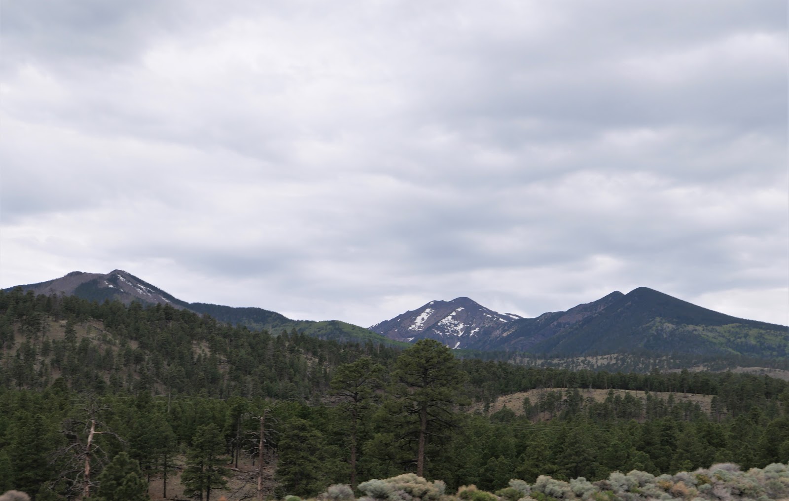
It was a hot and windy ride and we were glad to see the snowy San Francisco peaks in Flagstaff where we enjoyed a few miles of cooler temperatures. Like so many places in the Southwest, the San Francisco peaks were named by Franciscan friars doing missionary work in the area in 1629.

We turned off Route 89 in Flagstaff and headed south on I-17. As the elevation dropped from 7,000' in Flagstaff to 3,000' in Camp Verde the temperature rose again. Unfortunately,  a combination of an accident on Route 169 and a brush fire further south on I-17 made us take a detour that added about 45 minutes to our trip.

It's been a fantastic 4 days of motorcycle riding, and all within about 8 hours of home. We're looking to miles more of exploring on the BMW.


Friday, May 29, 2020

Utah Route 12 - An All American Road

Thanks to Butler Maps, we decided to ride north a few miles out of Hatch, Utah where we're staying for 3 nights, then head east on Route 12 - a scenic byway known as an All American Road. All American roads offer unique landscapes that aren't seen anywhere else, and we enjoyed a wide variety of them today on our 200 mile ride.


The ride started off with a huge 'wow' factor as we rode past the red stone hoodoos in Red Canyon., which is part of Bryce Canyon National Park. The hoodoos are unique rock formations that have been weathered and eroded into fantastic shapes. Route 12 goes through two tunnels as it twists and turns.


As we continued east, the view opened up and the colors of the rocks changed to creamy white.


Once we rode through the small town of Escalante, named after Silvestre Velez de Escalante, a Franciscan missionary and a member of the first European expedition into southern Utah in 1776 from Santa Fe, New Mexico, the landscape changed again into huge, rounded weathered boulders that extended as far as we could see.


This part of Route 12 is a motorcyclist's dream - lots of twisting, winding turns, elevation changes including a 14% grade at one point, and almost no traffic.


We stopped for lunch at our half-way point in the small town of Boulder at the base of Boulder Mountain. The Burr Trail Grill is nestled under cottonwood trees that provided a shady outdoor dining patio for a cool spot to enjoy lunch.


After lunch we retraced our route heading west on Route 12 watching the changing scenery and the storm clouds building off in the distance.


We stopped in Red Canyon for a photo opp with the motorcycle.


We definitely plan to ride through this area again, exploring more of the scenic byways on our BMW.


Thursday, May 28, 2020

US Route 89 north to Hatch, Utah

We're excited to finally be on an overnight motorcycle trip to Hatch, Utah so I can run the Vacation Races Bryce 60k on Saturday. The race starts only about 4 miles outside Hatch, which according to the 2010 census has a population of 133. Luckily there are a couple of motels and restaurants. 

We left home just before 8am, knowing this would be the hottest day so far this year. It was 71 degrees at home, mid-80's in Flagstaff, and in the mid-90's in Page. Once we got to Flagstaff, we rode north on highway 89 all the way to Hatch, 360 total miles for the day. 


The San Francisco Peaks in Flagstaff still have snow on the top, but just a few miles further north on 89 we had to stop for road construction for 9 minutes and the temperature was 94 degrees. I counted 68 cars heading south before it was our turn to get back on the road.

The landscape changed to a high, dry, barren desert with eroded rock piles lining the road.


As we continued north on 2-lane 89 through the Navajo Nation, sandstone cliffs rose up to the east. 


We came to a "Y" intersection where 89A heads west toward the North Rim of the Grand Canyon, and we stayed on 89 up through a mountain pass toward Page. The original highway is 89A; 89 toward Page was constructed in the 1960's to serve building the Glen Canyon Dam in Page.


89 goes over the Glen Canyon Dam and as we headed north we could see Lake Powell to the east.


Just a few miles north of Page we entered Utah and the landscape changed again to hot, dry, barren high desert.


We steadily gained elevation the further north we rode. Instead of washed-out colors and rocky cliffs, we started to see green grass, trees, and even water in the creeks.


We pulled into the Hatch Station motel about 6 hours after we left home in Prescott, AZ after a beautiful ride on US Route 89. Tomorrow we plan to ride through Bryce National Park and enjoy some twisty riding through this stunning part of the country.

Saturday, May 2, 2020

First ride to Flagstaff for 2020

Within the last week the temperature warmed up 10-15 degrees and it's finally great weather for a motorcycle ride to Flagstaff. At about 7000' elevation, Flagstaff is about 10 degrees cooler than our home in Prescott at 5400'. It was in the mid-70's when we left home about 10am and in the low 70's by the time we arrived in Flagstaff a little over 2 hours later.

Our original plan was to ride north on I-17 to Camp Verde where we would take AZ 260 east until we turned north to ride by Lake Mary. We were only about 10 miles outside Camp Verde when Mike saw the traffic stopped ahead of us, and then we noticed a medevac helicopter swoop in for a landing. We could potentially be stopped for a couple of hours, so we turned around and got back on I-17 north to Flagstaff. As Mike did a U-turn, I saw bright pink flowers on the cactus along the highway. To see flowers in the high desert, you have to slow down and look carefully.


I-17 is not as scenic, but we wanted to get to Flag around noon to eat lunch at our friends' BBQ food truck. Mike had the brisket sandwich and I chose the pulled pork. Both came with a choice of a side and chips. There was a steady line of people lined up to get their take-out lunch and as soon as we took the first bite of our sandwiches, we understood why - this is excellent BBQ! Be sure to check out their website to find out when they're open and stop by.


We decided to head home through Oak Creek Canyon and Sedona, hoping that it's too early in the season for crowds. It seems like every time we ride this way there is more traffic than we expect, and today was no exception. It's still a gorgeous ride on AZ 89 that twists and turns through switchbacks as dropped down through the Colorado Plateau.


Oak Creek is one of the rare Arizona streams that has water all year long, and especially during hot summer days people flock to the creek to sit in the cold water pools and enjoy the breathtaking scenery. It's not quite summer yet, but there were plenty of people playing in the water as we rode by.

We rode 250 miles and enjoyed a delicious BBQ lunch - what better way to enjoy a sunny day in May?