Showing posts with label Continental Divide. Show all posts

Tuesday, July 25, 2023

Riding home: familiar and new Colorado roads

 We started off the third and last day of our motorcycle trip Monday morning in Leadville, looking forward to more high mountain passes and a road we haven't yet ridden. We started off riding south on US 24, looking out over the snowy Rockies.


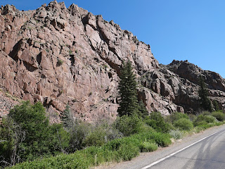
Soon the highway started curving and winding along rocky cliffs cut by the Arkansas River that starts near Leadville and ends 1469 miles later at the Mississippi in Arkansas.


We saw a few fly fishermen but no rafts on the river. Soon after we started riding along the Collegiate Peaks, a 57 mile stretch of the largest concentration of mountains over 14,000' in the United States.


We've ridden this way many times, but I'm always awed by the sight of these towering mountains, and even more impressed with hikers who climb them.

South of Buena Vista US 24 meets up with US 285, continuing south past more of the Collegiate Peaks.


In Poncha Springs we turned west onto US 50 and started winding our way up Monarch Pass our highest point for today at 11,312'. There's a ski area just east of the summit, and the gondola is open in the summer to take visitors for a sky-high view of the area.


After riding out into a broad valley, we turned south onto CO 114 - a road we had never been on. To our delight, the first 23 miles were freshly paved, and with no other traffic in sight we zoomed along the road.


We knew more fun was in store when we started seeing road signs warning about twisting curves.


The ride through Cochetopa Canyon is beautiful, with sharp turns through the rocky canyon.


We started seeing signs warning about road construction, and soon came upon the end of the newly paved section of highway. We crossed another pass - this time North Pass at 10,010' that travels along the Continental Divide. This was one of the original routes through the Continental Divide as it's a relatively gentle climb and descent - for a motorcycle, but not for someone with a horse and wagon!


CO 114 ends at Saguache where we turned once again onto US 285 south. We rode this route through the San Luis Valley in reverse on the first day of this trip, and started thinking about where we might stop for lunch as we passed bright green irrigated fields bordered by dusty brown desert.


We stopped in Del Norte on US 160W for lunch. It's often challenging to find a restaurant open on a Monday, and we were lucky to find the Three Barrel Brewing Company open 7 days per week. Leaving Del Norte we had about 90 miles left on our trip, riding over Wolf Creek Pass at 10,856'. This is a busy highway with trucks and RVs, and because the road has several tight turns and steep elevation changes, there are runaway truck ramps - just in case.


Riding down the Pass into Pagosa Springs we were just a few miles from home. We rode through incredibly beautiful areas over these past three days, yet the final stretch toward home is one of the most gorgeous areas in the entire state.


Wednesday, June 9, 2021

Twisting, sweeping turns through the Rocky Mountains

 We started this morning wandering around Glenwood Springs, Colorado, trying to find CO 82 East. We'd see a sign, get turned around, take a wrong turn on the extremely confusing roundabout, and finally stopped and asked directions. It was worth it, because CO 82 East heads directly toward 12,965' Mt. Sopris in the Elk Mountain Range of the Rockies just outside Glenwood Springs. 


The day just kept getting better as we turned south on CO 133, riding along the fast-moving White River on the West Elk Scenic Byway


The road climbs up 8% grades to McClure Pass, winding to the 8755' summit then twisting down the other side.


Like many of the mountain passes in Colorado, the Ute Native Americans were the first to traverse this area, followed by the Spanish in the late 1700's. It's difficult to comprehend how miners and ranchers drove their wagons up the steep grades when this was a rutted dirt road. 


CO 133 winds through Paonia, named for numerous peonies in the area (evidently the early settlers didn't know how to spell), and now home to farms, orchards, and wineries.


Staying on the Elk Loop Scenic Byway, we picked up CO 92 East, continuing through green ranches until the road started climbing, twisting, and turning in the Curecanti National Recreation Area


Steep cliffs drop down to the Gunnison River and reservoirs formed by three different dams and hairpin turns lined with wildflowers and aspens snake through the mountains.


We turned east on US 50, passing by the Blue Mesa Reservoir, then turned south on Colorado 149.


CO 149 from Blue Mesa Reservoir to South Fork through the San Juan Mountains was named the Silver Thread Scenic Byway in 1990.


We stopped in Lake City, incorporated as a silver mining town in 1875, for lunch at the Lake City Cafe, a superb restaurant in a gorgeous setting. Although home to only about 450 residents, it's a busy tourist center with over 400 buildings listed on the National Register of Historic Places.


After lunch we continued south on CO 149, twisting our way up to Slumgullion Pass at 11,530'.


With grades up to 9%, this is one of the steepest paved maintained roads in Colorado. This area is part of the Slumgullion Earthflow National Natural Landmark where about 700 years ago a large chunk of decomposing volcanic rock slid down the mountain to form a natural earth dam that blocked the Lake Fork of the Gunnison River and formed Lake San Cristobal (the lake that gives Lake City its name). 


CO 149 took us through Creede where two major rivers start:  the San Juan and the Rio Grande.


CO 149 ends at US 160, and is also the end of the Silver Thread Scenic Byway. We headed west on US 160 to Wolf Creek Pass and the Continental Divide. Traffic came to a halt right at the top of the Pass due to a truck pulling a camper that caught fire. We got off the motorcycle, walked around, and read the signs about the Pass at 10,857' for about 25 minutes before we were able to continue down the mountain.


We rode 307 miles today, almost exclusively on scenic byways through some of the most beautiful areas of Colorado. We're stopping for the night in Pagosa Springs at 7,126' above sea level in the San Juan Basin. 


At Hermit's Rest in the Curecanti National Recreation Area


Sunday, August 2, 2020

7th day on the BMW riding through the Rockies

We woke up to temperatures in the mid-50's in Gunnison, Colorado at 7,703' elevation and started the day's 175 miles heading east on US 50 through ranches and farms.


Soon we started climbing as we headed up and over The Sawatch Mountain Range on Monarch Pass.


We crossed the Continental Divide - again - at 11,312'


This isn't a narrow, twisting road with hairpin turns; rather it's an industrial-strength highway with easy, sweeping turns that can carry truck traffic across the state.


After descending to the valley, we headed north on US 285 toward Buena Vista. For the next few miles we watched the towering Collegiate Peaks, each at or above 14,000' elevation to the west; and the Arkansas River to the east.


The Collegiate Peaks are named after the Ivy League colleges in the East:  Mt. Harvard, Mt. Yale, Mt. Princeton.


The Arkansas River starts near Leadville and flows south and east to the Mississippi. This section is a favorite for kayakers and white water rafters.

It was time to start climbing again, this time up the twisting Independence Pass on county route 82. We passed Twin Lakes, two large, glacial lakes at the base of Mt. Elbert, at 14,440' the highest peak in Colorado and the second highest in the Lower 48.


Since it's a beautiful Sunday in early August, there was quite a bit of traffic, including the most motorcycles we've seen in one day on this trip. That meant we rode at a slower than usual pace while we enjoyed the hairpin turns and twisties.


We saw numerous signs of recent avalanches, including one section of the highway that was recently repaired due to an avalanche sweeping across this section of the road.


As we continued climbing the road snaked along rocky cliffs so close we felt like we could touch them, with long, steep drop-offs thankfully on the other side of the road.


We finally rode above the treeline, passing isolated spots of snow as we neared the summit at 12,095'. 


We crossed the Continental Divide for the second time today and descended down even narrower sections of highway into Aspen.


We rode through vast stands of aspens on both sides of the pass, and it makes sense that the mining town of Ute City changed its name to Aspen in 1880. 


County Route 82 goes right through Aspen, and then it was only a few miles to Basalt where we stopped for lunch before continuing on to our destination for the next 2 nights:  Carbondale. We were surprised that the temperature this afternoon is in the low 90's, but then we're at the lowest elevation on our trip so far:  6,427'. Carbondale was founded as a farming community and today is a tourist and skiing center. 

We're looking forward to a shorter ride tomorrow and exploring Carbondale on foot before we continue on our wandering route through the Colorado mountains on Tuesday.