Tuesday, September 29, 2020

Riding home from Zion

We left La Verkin, Utah about 8:30am local time, heading home after a weekend that included a ride through Zion National Park and a 13.5 mile trail race yesterday.


Riding through the vast southwestern part of the country, where the road stretches before us to the horizon and we can look out over a valley to the mountain ranges 100 miles distant, makes us appreciate the small details. A few cattle grazing in the dry scrub brush, birds lazily swooping on the updrafts, a couple of trees next to an abandoned homestead, the feel of the wind  as we zoom down the almost empty 2-lane paved road.


We rode east on Utah 59, which becomes Arizona 389 and entered the Arizona Strip, the remote, arid, northernmost part of Arizona that lies north of the Grand Canyon. Indigenous people lived in this area for at least 8,000 years and Spanish explorers first saw the South Rim of the Grand Canyon in the 1500's. The first Europeans didn't arrive to this more remote section of present-day Arizona until the late 1700's.

We picked up US 89A in Fredonia and gradually started to climb into the pine forests of the Kaibab Plateau.


We enjoyed the cooler temperatures at this higher elevation as the road curved and climbed to almost 8,000' elevation before we started to wind down into the valley along the Vermillion Cliffs National Monument, known for sherbet-colored swirls of slickrock and towering cliffs.


We crossed over the Colorado River and continued south on US 89 through the Navajo Reservation until we started to see the San Francisco Peaks, a mountain range just outside Flagstaff that contains Humphrey's Peak, the highest mountain in Arizona at 12,633'. After a quick stop in Flagstaff for lunch, we continued toward home riding on I-40 west until we turned off on the much less traveled AZ 89.

We love long motorcycle trips where we spend a few weeks on the road exploring new areas, and also relish a weekend trip and the opportunity to revisit familiar roads. With cooler weather coming, we'll change up our travels and head south instead of north, hopefully within the next couple of months.


Friday, September 25, 2020

Riding through Zion National Park

 We've ridden through areas with amazing scenery, on tightly twisting and curving roads through the Alps, over high mountain passes where we could see for miles, and today we rode through yet another area with fantastically colored rock formations and sheer, towering cliffs:  Zion National Park


Zion sits along the Colorado Plateau, where over millions of years rocks and sediments were uplifted, tilted and eroded. According to the National Park Service, the bottom layer of rock at Bryce Canyon (where we spent Memorial Day weekend) is the top layer of rock at Zion. The bottom layer of rock at Zion is the top layer at the Grand Canyon, about 100 miles south of Zion.


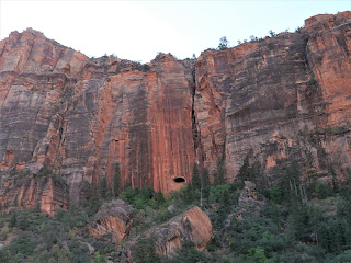
Look closely at the photo above - the opening in the rock face is part of the 1.1 mile long tunnel started in the late 1920's and completed in 1930. Because today's vehicles, especially many RVs, are large, they can't easily pass through the narrow tunnel. Any vehicle that is 7'10" wide and/or 11'4" tall or larger is required to have a tunnel permit. Thank goodness we were on the motorcycle!


We continued east on Utah Route 9 to the junction of US 89 at Mt. Carmel, then turned around and retraced our route back west.


We stopped at the viewpoint for Checkerboard Mesa in the photo above where we talked with two motorcycle riders from the Phoenix area. 

The section of Utah Route 9 through Zion National Park is only 14 miles long, but the twisty narrow road, hairpin turns, and jaw-dropping views makes this a drive you want to take slowly and savor.


Thursday, September 24, 2020

345 miles today from home in Arizona to La Verkin, Utah

 We started a 4-day trip this morning, leaving our home in Prescott, Arizona and heading north first to Flagstaff, and then continuing north on US 89 through the high desert of the Navajo Reservation.


This landscape looks almost other-worldly, and even though we've ridden this way several times, we never get tired of looking out over the sand and rocks.

We've been looking for a shiny tanker truck so we could take a photo of us on the BMW as we ride by, and today we finally find one:


Soon after this photo, the BMW's odometer turned over to 26,000 miles and we did a little happy dance on the bike for all the fun we've had over the past 2.5 years.

We turned left onto US 89A, and stopped at Marble Canyon to walk across the Navajo Bridge over the Colorado River. This is considered the beginning of the Grand Canyon, and is where the historic Lee's Ferry was located. For about 55 years the ferry was the only way to cross the Colorado River, until the first bridge was built in 1929. A new bridge designed for larger trucks was completed in 1995, and the old bridge is now reserved for pedestrians.


We continued west on US 89A past the Vermillion Cliffs National Monument near the Arizona/Utah border where the Paria Plateau drops 3,000' to the valley floor.


After passing by Vermillion Cliffs, the highway winds and climbs up the Kaibab Plateau and the landscape changes once again, this time to dense forests of tall pines. We stopped for lunch in Jacob Lake where we couldn't pass by the large, delicious homemade cookies. 89A continues west at this point, winding through the pine forests that unfortunately were decimated by the Magnum Fire in June of this year.


We wound our way down an average 6% grade off the top of the Kaibab Plateau to the high desert floor below us, and when we reached Fredonia we turned west on State 389, riding through part of the Kaibab Paiute Reservation only 50 miles north of the Grand Canyon.


The temperature rose into the mid 90's and we were glad we only had a few miles left until we reached La Verkin, Utah where we're staying for 3 nights. We're looking forward to some gorgeous motorcycle riding!


Wednesday, August 12, 2020

3400 miles, 17 days, 4 states on the BMW

It's bittersweet whenever a motorcycle ride comes to an end, and especially so after a fantastic 17-day, 3400 miles in four in our favorite states:  Arizona, Utah, Wyoming and Colorado. We planned a short, 96 mile ride today to beat the heat (and have time to do laundry) from Flagstaff to Prescott, Arizona.

Flagstaff sits at about 7,000' elevation and the temperature was in the mid 50's when we hopped on the BMW at about 7am. We headed south on I-70, riding through the tall pine forests that surround Flagstaff. As we continued south, the elevation dropped and the landscape changed to shorter pine trees in less dense forest as the temperature climbed into the low 70's.

I-70 skirts Sedona, but we could see some of the famous red rock formations off in the distance.

By the time we reached the Verde Valley about 55 miles south of Flagstaff, we had dropped to around 3,000' elevation and the temperature was in the high 80's. We no longer saw stands of tall pine forests, but rather scrubby chaparral and even cactus, reminding us that much of Arizona is high, dry, hot desert.

Thankfully the Verde Valley is the lowest, hottest point on our trip, and when we started climbing the temperature cooled into the mid 70's again. When we turned onto US 169 we were only 30 miles from Prescott and the dry grassland told us that the monsoons which provide much needed rain in the summer had not been active the previous 2 weeks while we were away.

As we rode along the familiar highway this morning, I thought about everything we had seen during our trip: mountain passes in the Rockies above 10,000', cold mountain reservoirs, rivers and streams that actually contain water (unlike most of the rivers and streams in Arizona that only have water after a rain or sometimes during snow melt), miles of riding without seeing another vehicle, a couple of fabulous dinners and times when we couldn't find a restaurant and resorted to an energy bar for our meal, a soak in the mineral hot springs in Saratoga Wyoming, a weekend with our sons in Silverthorne Colorado, hairpin turns, twisting mountain roads, long straight highways that stretch almost to the horizon. We're ready to head out again!


Tuesday, August 11, 2020

Riding the BMW from Colorado into Arizona

 Today's ride took us from the lush green mountains around Pagosa Springs, Colorado into the wide-open desert in northern Arizona over 370 gorgeous miles.

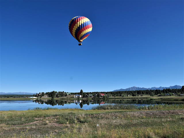
It was fun to see a hot air balloon as we started our ride today heading west on US 160. We rode past Chimney Rock National Monument at the southern edge of the San Juan Mountains, where over 200 homes and ceremonial buildings of the Ancestral Puebloans are preserved.

160 West took us through Durango and Cortez through the Southern Ute Reservation and the Ute Mountain Reservation, reminders that people made this area their home for thousands of years before Europeans arrived. We reached 3,000 miles for our trip - so far - in Cortez.

After riding through the San Juan mountains outside Durango, we rode past Mesa Verde National Park, established in 1906 to preserve more sites of the Ancestral Puebloans, including 600 cliff dwellings. The park towers at 6,000'-8,500' above the surrounding valley.

Whenever we head home from a motorcycle trip north of us, we have to ride through the Navajo Reservation which covers 27,000 acres in Arizona, Utah and New Mexico. That's slightly larger than the entire state of Tennessee! Small towns are few and far between in the Navajo Nation, and with COVID restrictions there are many closures. We make sure to fill up the BMW with fuel before we get onto the Nation and not stop at all, if possible. Today we stopped in Cortez which sits at 6,200' elevation in the Montezuma Valley in southwestern Colorado. As we headed south on US 160, we left the green mountains behind us as we entered the desert. For the next part of our trip, the only green we would see are areas that are irrigated.

Unlike riding the twisting, curving roads through the Rocky Mountains the past few days, today's ride was on straight roads which allowed us to zoom along the highway at faster speeds. We crossed the San Juan River which marks the boundary between the Ute Mountain Reservation and the Navajo Reservation and then past Four Corners where the states of Utah, Arizona, Colorado and New Mexico meet.

The landscape changed again as we rode into Kayenta, a town of about 5,000 people in the Navajo Reservation. The red rock cliffs and buttes seem to change color and even shape with the changing light from sun to cloudy skies, making this a mesmerizing ride. 


US Route 160 ends at US 89, where we turned south toward Flagstaff, Arizona, our stop for the night. The temperature rose to 99.5 degrees and thankfully a partly cloudy sky kept it a bit cooler as we rode toward the San Francisco Peaks.

Flagstaff sits at about 7,000' elevation so the temperature dropped into the low 80's. Tomorrow is a short 2 hour ride home, and the end of our 17 day motorcycle trip.