Showing posts with label Colorado Rockies. Show all posts

Tuesday, August 11, 2020

Riding the BMW from Colorado into Arizona

 Today's ride took us from the lush green mountains around Pagosa Springs, Colorado into the wide-open desert in northern Arizona over 370 gorgeous miles.

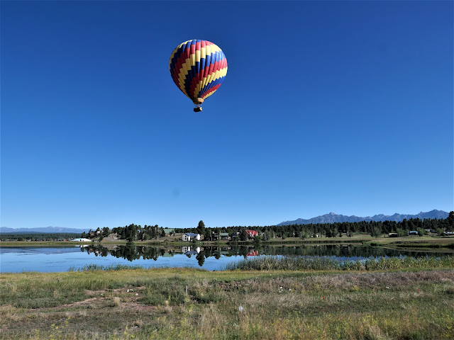
It was fun to see a hot air balloon as we started our ride today heading west on US 160. We rode past Chimney Rock National Monument at the southern edge of the San Juan Mountains, where over 200 homes and ceremonial buildings of the Ancestral Puebloans are preserved.

160 West took us through Durango and Cortez through the Southern Ute Reservation and the Ute Mountain Reservation, reminders that people made this area their home for thousands of years before Europeans arrived. We reached 3,000 miles for our trip - so far - in Cortez.

After riding through the San Juan mountains outside Durango, we rode past Mesa Verde National Park, established in 1906 to preserve more sites of the Ancestral Puebloans, including 600 cliff dwellings. The park towers at 6,000'-8,500' above the surrounding valley.

Whenever we head home from a motorcycle trip north of us, we have to ride through the Navajo Reservation which covers 27,000 acres in Arizona, Utah and New Mexico. That's slightly larger than the entire state of Tennessee! Small towns are few and far between in the Navajo Nation, and with COVID restrictions there are many closures. We make sure to fill up the BMW with fuel before we get onto the Nation and not stop at all, if possible. Today we stopped in Cortez which sits at 6,200' elevation in the Montezuma Valley in southwestern Colorado. As we headed south on US 160, we left the green mountains behind us as we entered the desert. For the next part of our trip, the only green we would see are areas that are irrigated.

Unlike riding the twisting, curving roads through the Rocky Mountains the past few days, today's ride was on straight roads which allowed us to zoom along the highway at faster speeds. We crossed the San Juan River which marks the boundary between the Ute Mountain Reservation and the Navajo Reservation and then past Four Corners where the states of Utah, Arizona, Colorado and New Mexico meet.

The landscape changed again as we rode into Kayenta, a town of about 5,000 people in the Navajo Reservation. The red rock cliffs and buttes seem to change color and even shape with the changing light from sun to cloudy skies, making this a mesmerizing ride. 


US Route 160 ends at US 89, where we turned south toward Flagstaff, Arizona, our stop for the night. The temperature rose to 99.5 degrees and thankfully a partly cloudy sky kept it a bit cooler as we rode toward the San Francisco Peaks.

Flagstaff sits at about 7,000' elevation so the temperature dropped into the low 80's. Tomorrow is a short 2 hour ride home, and the end of our 17 day motorcycle trip.

Wednesday, August 5, 2020

Climbing over high altitude mountain passes on the BMW

After enjoying a rest day in Carbondale, Colorado, we were ready for a longer day on the BMW, and it started off with a bang as we headed south on Colorado 133 with views of 12,965' Mt. Sopris in front of us.


133 sweeps and twists alongside the Crystal River, making for a fun and beautiful start to our day.


Route 133 is part of the West Elk Loop Scenic Byway as it travels through the West Elk mountain range in the Rockies. There was hardly any traffic as we wound our way through rocky canyons and then climbed up through aspens on McClure Pass that tops off at 8,769'.


We descended into the North Fork Valley where the landscape changed completely from green mountains and rivers to dry, brown landscape that reminds us of parts of northern Arizona as we rode through Hotchkiss where we turned west on Colorado 92 toward Delta.


In Delta we turned south on US 50 that travels through the Uncompahre Valley Today this is prime, irrigated agricultural land and historically it was the home of the Uncompahre band of the Ute Native American tribe. Spaniards were the first Europeans to explore this area in the 1770's, giving Spanish names to many mountains (the San Juan range) and rivers. Gold was discovered here in 1858 which led to an influx of European settlers.


We picked up US 550 heading south from Montrose, and the real fun of the day began as we passed Ridgway, gateway to the San Juan Mountains and the start of one of our favorite motorcycle rides on the San Juan Skyway scenic byway.


We climbed from Ridgway to Ouray, named for the chief of the Uncompahre band of the Utes. Ouray is an old mining town at 7,792' elevation, founded by miners searching for silver and gold. Today it's a mecca for hiking, off-roading - and zooming around tight hairpin turns, twisties that hug the towering rock walls on one side with thousand-foot drop-offs on the other side (no guardrails!) and so much jaw-dropping scenery that we never tire of riding this fantastic road through the mountains.


There is still plenty of mining operations evidence in this area, and it's fun to try and spot the remnants of the Red Mountain Mining District tucked into the pine forest or sometimes right out in clear view alongside the road.


We crossed the top of  Red Mountain Pass at 11,018' descending with wide, sweeping turns into Silverton.


After passing Silverton, we climbed up and over Molas Pass at 10,912' followed quickly by Coal Bank Pass at 10,610' and then it's downhill all the way to Durango.


We stopped for lunch just before we reached Durango, enjoying pulled pork sandwiches at Serious Texas BBQ. Durango was founded in 1880 to serve the San Juan mining district, and is named after Durango, Mexico. It's the largest city, with about 17,000 people, in the area and we really noticed how much the city has expanded since our last visit a couple of years ago. 

We took US 160 east from Durango toward Pagosa Springs, our stop for the night. Along the way we passed Chimney Rock National Monument a protected archeological site of the Ancestral Pueblans who lived here about 1000 years ago.


Pagosa Springs is the site of several hot mineral springs, but unfortunately we don't have time on this trip to take advantage of their healing properties. We're headed over more high mountain passes in the Rockies tomorrow!

Saturday, July 12, 2014

Colorado mountain passes and rivers on the BMW motorcycle

Day 5 of our motorcycle trip in Colorado started with a bear.

Mike and I went for a walk before breakfast, headed for the path along the Roaring Fork River in Aspen. Just before we reached the path Mike spotted a large black bear leisurely crossing the road. Deciding caution was in order, we walked through the streets of Aspen instead of following the path.

We didn't see other bear as we headed up Independence Pass but we did see sweeping views of the Sawatch Range as the narrow road twisted and climbed through the aspens at lower elevations and pine trees as we neared the top.


On the way to the top of the pass we stopped to see the ghost town of Independence, founded in 1879 when gold was discovered in the area. At one point over 300 people lived in this remote mountain area at 10,000' elevation, but when the gold ran out the settlement couldn't survive. According to legend, during the worst recorded storm in Colorado history in the winter of 1899, the remaining 75 people made wooden skis and escaped down to Aspen when they ran out of food.


The road kept climbing until we reached the Continental Divide at 12,095'. We walked on a paved path through the alpine tundra above the treeline with views of Mt. Elbert, at 14,440' the highest mountain in Colorado and the second highest in the contiguous United States behind Mt. Whitney in California.


We zoomed down the Pass around hairpin turns and long sweeping curves into the town of Twin Lakes.


Less than 200 people live at 9200' elevation in this beautiful area at the base of Mt. Elbert.


We turned onto Colorado Route 24, but didn't leave snow-topped mountains behind as we traveled the Collegiate Peaks Scenic Byway, with views of several of the fourteeners (mountains over 14,000' elevation).


We continued on Route 50 into Salida, with the Collegiate Peaks to our right and the Arkansas River to our left. We sat outside on the deck of the Boathouse Cantina watching kayaks navigate the river rapids and mountain bikers climb the surrounding hills.


As we left Salida dark storm clouds formed overhead and we stopped to put on rain gear. The temperature dropped and a light rain fell as we climbed Monarch Pass at 11,312'. We saw several motorcycles throughout our ride today, but I was surprised to see two heavily packed Ruckus scooters slowly winding up the road at 20-25 mph.

After we descended the 7% grades the sun came back out and the rain gear came off. We rode the last few miles through wide valleys into Gunnison, arriving at our hotel at 2:30 pm. Our son Nate recommended that we ride up Cottonwood Pass through the Gunnison National Forest, so we unpacked the bike and headed back out.


The Taylor River rushes next to the road on the way up to Cottonwood Pass, and we saw people in bright-orange rubber rafts navigating the rapids and fisherman wading in the shallow areas.


Our luck ran out when the sky turned black and lightning lit up the sky nearby. We turned around before we reached the Taylor Reservoir at the top of the Pass and retraced our route back to Gunnison.


We rode 145 miles today through some of the highest mountain passes in the United States. Tomorrow we continue through the Rockies to Durango. Hopefully the day won't start with another bear sighting.