Monday, June 7, 2021

Black Hills, Thunder Basin National Grasslands and more

 We're back on the road today after a long weekend outside Deadwood, SD. Our route took us southwest on US 85 on winding roads with sweeping turns through the Black Hills National Forest


We crossed over into Wyoming and in Newcastle turned west on US 16 and rode out of the Black Hills. We followed train tracks for a few miles, and Mike was excited when the engineer blew the train whistle as the long train of coal cars rumbled past. Wyoming is the nation's top coal producer, and our route took us through the Powder River Basin where the top 10 producing coal mines are located. 

Just before lunch the odometer rolled over to 31,000 miles which mean we've ridden about 1300 miles so far on this trip. We were lucky today with our lunch stop - Remy's Diner in Upton, Wyoming. The owner told us today is the 21st anniversary of her business that features homemade foods, and we enjoyed fabulous chocolate malts along with our sandwiches in a friendly, inviting atmosphere. Don't miss it!


We turned west onto Wyoming 116 after looking at the map during lunch and realizing we missed our planned turn a few miles back. WY 116 took us through Thunder Basin National Grassland. The highway stretched straight out in front of us as far as we could see, occasionally taking a wide sweeping turn.


We saw cows, sheep, and plenty of deer but very few vehicles or houses.


WY 116 took us to WY 450 which was our original planned route. Listed on the Butler motorcycle map as a lost highway, or a road that has faded center lines and long miles without signs of people that make them seem lost in time. This is a semi-arid climate with few trees, and we could imagine settlers traveling west in covered wagons.


We felt lost in time until we passed huge coal mines and saw more trains ferrying cars of coal east. We took a quick jog for 3 miles on WY 59N and then turned west onto WY 387, passing a couple of small towns that support the coal and oil industry in this area. The Bozeman Trail, named after John Bozeman who established this route in the 1860's to connect the gold rush territory of southern Montana with the Oregon Trail in eastern Wyoming, crosses the highway and made us think of the vast difference between those early pioneers and us zooming down the highway on our BMW.


We picked up I-25 south for about 40 quick miles with the speed limit posted at 80 mph and unlike most interstates, very little traffic. Our stop for tonight is Casper, Wyoming, the second largest city in Wyoming with a long history of oil and cowboy culture. It was 93 degrees when we stopped late in the afternoon, glad to take advantage of air conditioning before we continue our ride tomorrow into Colorado.


Sunday, June 6, 2021

Denver to Whitewood, South Dakota

 We left Denver first thing in the morning and decided to ride north on I-25 past Cheyenne, WY since we had a long way to go and it was a hot day. I spent my time looking west to the Front Range of the Rockies while Mike navigated the traffic.


When we crossed into Wyoming the mountains disappeared, replaced by green prairies as far as we could see.


This wide-open country is known for strong winds and fierce winter storms. Luckily today we had neither, but we did see miles of snow fencing.


As we continued north, the landscape changed to rocky cliffs and hills covered with trees in this southwestern corner of the Black Hills. The Black Hills National Forest covers 1.2 million acres with only 10% in Wyoming and the rest in South Dakota. The Black Hills got their name from the dense ponderosa pines that look black from a distance, and we enjoyed the change in scenery as well as the sweeping highway turns through the area.


We're staying at a VRBO in Whitewood, SD for the weekend with our sons, their girlfriends, and dogs where we sit outside on the porch and watch the wildlife in the fields. We're back on the road Monday, continuing our trip west into Wyoming - and more hot weather.


Wednesday, June 2, 2021

Wide open valleys, snow-capped mountains, and city riding

 Today had a little bit of everything. We started out in Buena Vista, CO, with partly cloudy skies that allowed the sun to bounce off the glittering snow-capped Sawatch Range mountains that contain several peaks over 14,000'


We headed north on US Route 285 which winds through South Park, a high altitude basin that covers more than 1000 square miles. This is wide-open ranch country at about 9,000' elevation and as we watched the clouds roll in we thought about the hardy and adventurous ranchers who settled in this area.


I started off the day wearing all my warm clothes, liners, and rain gear due to the cool temperatures in the mid 50's to low 60's plus the threat of rain. We stopped along Route 285 for Mike to pull on his rain pants just as the first raindrops started to fall. The rest of the day we rode in and out of rain as we crossed Kenosha Pass at 10,000' elevation, leaving South Park and riding through the Pike National Forest through the Front Range of the Rockies into the Denver area.

We started off the day with very little traffic, and ended up riding in 6-lane traffic into metropolitan Denver to stay with our son in Lakewood, CO. We're here for the next 3 days when we continue our motorcycle trip to Deadwood, SD.


Monday, May 31, 2021

A rainy ride through the Rockies

 The weather forecast wasn't great, with rain and intermittent thunderstorms forecast for the entire day. We opted to leave Pagosa Springs before 8am and wore all our warm clothes, liners, and rain gear as we rode east on US 160 through the Rio Grande National Forest.


We wanted to get over Wolf Creek Pass, at 10,857' at the top of the Continental Divide, before bad weather hit. Originally a 12' wide dirt road constructed in 1916, it's now a multi-lane paved highway with maximum 6.8% grade. 


Although the ski area on the east side of the summit is closed for the year, there's still a significant quantity of snow. We missed the rain, but the temperature dipped to 42 degrees as we zoomed down the mountain into the San Luis Valley, a 122 mile long, 74 mile wide high mountain valley home to small towns and agriculture. 


We turned northeast on Colorado 112 for a short stretch before heading north on US 285 through the valley with the northern part of the Sangre de Cristo mountain range to our right. The clouds dropped down below the tops of the mountains and we rode in and out of rain the rest of the trip.


We ended the day in Buena Vista, a beautiful mountain town at about 8,000' with normally gorgeous views of the Presidential Peaks. The weather should clear up tomorrow and we'll be able to see the mountains as we continue our ride north.

Into the mountains

We started off the morning riding east from Farmington, NM on US 64, riding out of the industrial/commercial area into open country, following the 2-lane paved highway as it swept and turned past high rock walls.


64 East took us through the Carson National Forest and then the Jicarilla Apache Nation in this rugged and beautiful part of northern New Mexico. 

We turned north on NM 17, riding through the small town of Chama, home of the historic Cumbres and Toltec Scenic narrow gauge railroad. Only 64 miles of narrow gauge tracks remain, and this year one of the original 1880's steam engines returns to service. 


Route 17 and the narrow gauge railroad snake through the Sangre de Cristo mountains, the southernmost range of the Rocky Mountains. This is gorgeous country, and we were excited to watch the elevation rise to 10,230' at the top of La Manga Pass once we crossed over into Colorado.


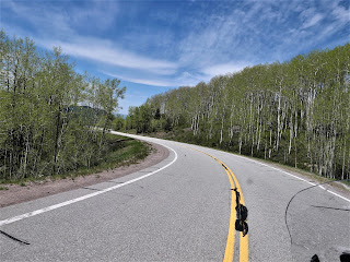
We turned around and retraced our route heading south on 17, crossing back into New Mexico and descending through groves of aspens.


We stopped for lunch at Fina's Diner in Chama where we sat outside in the large tent and watched the holiday weekend traffic, including a few motorcycles, zip past us on the highway. We turned north on US 84, crossed back into Colorado, and ended our day in Pagosa Springs.


We love seeing water running in the streams, green grass, and the snowy mountain tops which are so different from our home in Arizona. Pagosa Springs sits at about 7100' elevation on the Western Slope of the Continental Divide in an absolutely stunning part of the country. Our first day of the trip was all about straight roads through the desert, and today we enjoyed sweeping curves through the mountains.