The highway follows the twisting White River on the Western Slope of Colorado with irrigated green farmland nestled beneath the sandstone hills.
60 miles east of Rangely we came to Meeker, a town of about 2200 people that is the most populous town in this county - that tells you how wide-open this part of Colorado is. We had to stop quickly to let three deer cross the road in front of us in downtown Meeker before we continued north on Colorado 13 through Nine Mile Gap that tops off at 7,746'.
North of the town of Craig we passed by Fortification Rocks, a series of volcanic rocks that lifts up from the surrounding grassland. According to the sign at the Rocks, it's believed this area was used by local Native American tribes before battle; today it's more well-known as the home of many rattlesnakes.
North of Craig the meadows opened up on all sides and a stiff wind started to blow. We saw several miles of snow fences and signs for snowmobilers, a reminder that winter is difficult in this wide-open area.
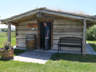
We crossed into Wyoming, our 4th state of this trip and crossed the Little Snake River and turned east on Wyoming 70 at the tiny town of Baggs, population 440 according to the sign. By this time we had been on the road for over 3 hours and were hungry for lunch. Luckily we saw a sign for the Little Snake River Museum, and thought there might be a shady spot to eat our energy bars. We were in for a most welcome surprise as the museum encompasses several historic buildings filled with interesting items. We spent a pleasant hour touring the well-kept area and enjoying a cold bottle of water and Klondike ice cream bar - a much better lunch than we anticipated!
Soon we rode into the Medicine Bow National Forest where 70E becomes known as the Battle Pass Scenic Byway, climbing through the heavily forested Sierra Madre mountains. The road is named for a battle between Native Americans and fur trappers in 1841.
Mike commented on the first aspens we have seen this trip, and they really were quaking in the windy conditions at this high elevation.
We passed many dirt roads heading off the side of the highway into the wilderness but saw very little traffic as we leaned into turn after turn, climbing our way to the top of the pass. We stopped at a sign that explained Thomas Edison visited this area in 1878 on a fishing trip, and looked out over a stunning view of a high mountain lake.
We continued climbing for a few more miles, reaching the summit at 9,955' at the Continental Divide.
We zoomed down the other side of the Pass through dry, arid country devoid of trees until we turned north onto Wyoming 230.
Even though storm clouds were building all around us, we didn't get wet as we pulled into the Riveria Lodge, our stop for the night in Saratoga. There are numerous hot springs in this area and we plan to visit one in the morning before we continue our ride southeast into Colorado - and more high mountain passes.


No comments:
Post a Comment