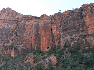
We've ridden through areas with amazing scenery, on tightly twisting and curving roads through the Alps, over high mountain passes where we could see for miles, and today we rode through yet another area with fantastically colored rock formations and sheer, towering cliffs: Zion National Park.
Zion sits along the Colorado Plateau, where over millions of years rocks and sediments were uplifted, tilted and eroded. According to the National Park Service, the bottom layer of rock at Bryce Canyon (where we spent Memorial Day weekend) is the top layer of rock at Zion. The bottom layer of rock at Zion is the top layer at the Grand Canyon, about 100 miles south of Zion.
Look closely at the photo above - the opening in the rock face is part of the 1.1 mile long tunnel started in the late 1920's and completed in 1930. Because today's vehicles, especially many RVs, are large, they can't easily pass through the narrow tunnel. Any vehicle that is 7'10" wide and/or 11'4" tall or larger is required to have a tunnel permit. Thank goodness we were on the motorcycle!
We continued east on Utah Route 9 to the junction of US 89 at Mt. Carmel, then turned around and retraced our route back west.
We stopped at the viewpoint for Checkerboard Mesa in the photo above where we talked with two motorcycle riders from the Phoenix area.
The section of Utah Route 9 through Zion National Park is only 14 miles long, but the twisty narrow road, hairpin turns, and jaw-dropping views makes this a drive you want to take slowly and savor.


No comments:
Post a Comment