Sunday, August 11, 2013

Senator Highway

Until our furniture and household goods arrive - hopefully this week - we have extra time on our hands to explore our new home in Prescott, AZ. This afternoon we took a quick ride around town, and it continually amazes me how I notice things on the bike that I never see while driving a car. A house perched high on a rocky bluff, a hawk circling above the pavement, a dirt road that snakes along the very edge of a steep hill, horses in a field along a busy road.

Our main objective was to ride on the pavement portion of the Senator Highway into the Bradshaw Mountains to the south of Prescott. I'm finding out that many paved roads turn to dirt as they enter the mountains, and the same thing happens with the Senator Highway. It was originally built in the late 1800's to connect mining towns to Prescott, and with the end of mining the road outlived its use. We plan to ride the entire Senator Highway, dirt road and all, but not today.


The two-lane paved road hairpins its way into the pine forests, and we saw signs for camps, lakes, and private roads along the way. The Senator Highway passes through Groom Creek with numerous hiking trails and national camping areas. When the pavement turned to dirt, we turned around, saving the rest of the road for another day.


Back in Prescott, Senator Highway becomes Mt. Vernon street, part of the national  historic district that surrounds the downtown area, and lined with cute cottages and imposing Victorian homes. This area looks more like the midwest than the southwest, complete with grass lawns and leafy shade trees.


We've been past the Yavapai casino many times, and today we rode up the steep road to the top of the bluff where the casino sits to check out the view.
 

One of the reasons we moved to Arizona is for new roads to ride, different landscapes to explore, and many more days of fun on the BMW. We're making a great start!

Thursday, August 8, 2013

First Arizona ride


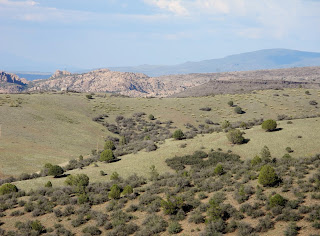
The view as we rode west from our house in Prescott, AZ is a lot different from the view we were used to in Vermont.

We're still waiting for our furniture and household goods to be delivered, so with time on our hands and a sunny day, we headed north on the BMW to Jerome, a quirky old mining town dangerously perched on the side of a mountain. Our plan was to take route 89A, which we knew wound through several twisty hairpin turns before reaching Jerome.

We thought we knew how to reach 89A, but spent 20 minutes circling Prescott and ending up back where we started. Not a bad ride since we're new to the area, but we still wanted to get to Jerome. We let the GPS take over and found 89A, the mountains, hairpin turns, steep ascents, and zooming downhill twisties. It's only about 30 miles from Prescott to Jerome, and the landscape changes drastically during that short stretch. We started in the flat valley just north of Prescott and as we entered the mountains tall pine trees covered the slopes and we spotted numerous dry creek beds.

We wandered the narrow, one-way streets in Jerome stopping in art galleries, treating ourselves to ice cream, and reading many of the signs that describe the wild life when Jerome was in its heyday in the late 1800's. Jerome was the fourth largest town in Arizona with 15,000 people, all due to copper mining. According to the historical signs, saloons, brothels and hotels enjoyed a brisk trade. Today about 500 people live in Jerome, catering to tourists.

We just rode 3200 miles from Vermont to Arizona, spending 5-10 hours each day on the bike. It felt good to take a short ride to a nearby destination, exploring the roads and towns around our new home.


Friday, August 2, 2013

Last day of the Vermont to Arizona adventure

We had a short ride planned today from Flagstaff to Prescott via way of Sedona. We drove this route in early July when we were in Prescott to buy a house, and knew it would be a fantastic motorcycle road with hairpin turns, lots of climbing, and gorgeous scenery.

Sometimes our plans take a wrong turn.

We left Flagstaff on Lake Mary Road, a beautiful drive along Lower and Upper Lake Mary. These lakes almost disappear during the dry season, but today both had enough water for people to be out in kayaks.


Mike set the GPS for Sedona, and when it pointed us off the paved highway onto a dirt forest road, we decided to see where the GPS took us. After a mile of rutted, rocky, and sometimes muddy forest road better suited to ATVs then motorcycles, the GPS indicated we had 148 miles to go to Prescott. We knew that Prescott was only about 50 miles away - by highway. At that point we followed the signs to I-17, a 12 mile ride that took us over an hour to complete. It's a good thing the BMW is a GS, built for off-road riding although probably not with full bags and an extra duffle. We saw no other people the entire trip, but did encounter one cow.


After the technical riding in the quiet Coconino National Forest it was jarring to turn onto I-17 with a 75mph speed limit. I-17 drops 3000' elevation in a few short miles before we started climbing again on our way to Prescott.


We planned this 3200 mile trip as a way to see new parts of the country, have some adventures along the way, and transition from living in Vermont to Arizona. We experienced many 'lasts' over the past two weeks:  the last time we saw many friends, the last time we lived in Vermont, and tonight the last night in a hotel before we move into our new home tomorrow. We've also enjoyed many 'firsts':  the first time we rode a motorcycle in Iowa, Nebraska, Colorado and Arizona; the first time we stayed in a motel that also had a drive-in movie theater, the first time we walked into our new home.


There are more changes in store over the next few weeks as we move into our new home and get settled in Arizona. We kept reminding each other over the past 9 days that the trip was about the journey, not just the destination. Now that we're in Prescott, AZ, it's time to plan more motorcycle trips. Stay tuned.


Thursday, August 1, 2013

9 states in 8 days

This is our 8th day of our motorcycle trip from Vermont to Arizona, and today we rode 447 miles from Monte Vista, Colorado in the San Luis Valley to Flagstaff in northern Arizona. All but 70 miles were on route 160 which took us through a variety of different types of landscapes.

We were excited to finally experience some true hairpin turns and twisting roads on our way to the top of the Continental Divide through the Wolf Creek Pass in the San Juan mountains of the Rockies. Tunnels, hairpin turns, and views far out into the distance made this ride one of our favorites on the trip, even though we stopped to put on all of our gear because the temperature dipped to 53 degrees!


Mike at the top of the Continental Divide


On the other side of the Continental Divide we rode past Chimney Rock, sacred to the Ancestral Puebloans. The hard sandstone Chimney Rock is over 535 million years old, part of an ancient seabed that was lifted up by volcanoes. Erosion by glaciers, wind, and rivers left the rock that towers 1500' over the surrounding area.


Nearby Mesa Verde was home to the Ancestral Puebloans from A.D. 600 to 1300 and today the National Park Service maintains nearly 5000 archeological sites and 600 cliff dwellings in this 81 square mile park. We visited here four years ago, and as we rode past today I remembered the amazing cliff dwellings we visited.

view of Mesa Verde as we approach from the east

Mesa Verde Cliff dwellings from our 2009 trip

The majority of our trip today took us through the Navajo Nation that covers 27,000 square acres in the Four Corners where Arizona, New Mexico, Utah and Colorado meet. It's the only place in the United States where four states meet exactly at one point.

our BMW in front of the Four Corners Monument

We stopped at the Four Corners monument to stretch our legs, try our first Navajo fry bread, and learn more about this area. The landscape is breathtaking and extremely rugged, and I kept wondering how people managed to survive here for thousands of years, and how they continue to live today in this remote area.

view at the Four Corners looking into Utah


We passed by craggy canyons, high sandstone cliffs, arid deserts with scattered herds of cattle and horses, and areas that looked like someone had dumped huge piles of sand and gravel but are part of the natural landscape.


look closely and you'll see the horses

Even with overcast skies and threatening rain, the temperature rose into the low 90's as we left the Navajo Nation and continued south to Flagstaff.


The rain caught up with us, and we stopped at a church when Mike saw lighning. We rode in and out of rain the last 20 miles, watching the worst of the storms to the east and west of us.


We were on the road for 10 hours today, giving us a short day tomorrow for our final ride into Prescott, AZ - our new home.